


Get to know Hualien County

Photo adjustments
Full-frame source proportionally resized and converted to WebP for display. No subject alteration. Source-supplied marks and edits remain; cards may crop the view.
- Administrative area
- County / city · 縣市
- Part of
- Taiwan
- Chinese name
- 花蓮縣
- Local areas
- 13 local areas
Area & population
- Area in the source
- 4,628.57 km²
- Administrative seat
- Hualien City
Source: cited geographic source, as of the dates shown.
Most of its population resides in the Huadong Valley, which runs north to south between the Central and Hai'an mountain ranges. Hualien's natural environment attracts many visitors and some of its natural attractions include Taroko Gorge, Qingshui Cliff, and Qixingtan Beach.
Tourist attractions
In 2023, Booking.com included Hualien as the only Asian city on its list of "Most Welcoming Cities on Earth." In 2024, Hualien was selected "Asia’s Top 9 Nature Destinations" by Agoda.
Explore Hualien County
Core places to explore, with English and Chinese names.
Hualien 花蓮
Qixingtan Beach 七星潭
Taroko National Park 太鲁阁国家公园
Shitiping Coastal Terraces 石梯坪
Mataian Wetland 马太鞍湿地
Lintianshan Forestry Culture Park 林田山林业文化园区
Liushishi Mountain Daylily Fields 六十石山
Liyu Lake, Hualien 鲤鱼潭
Ruisui Hot Springs 瑞穗温泉
Xiuguluan River Guided Rafting 秀姑峦溪正规漂流
Taroko National Park — Access Check Required 太鲁阁国家公园(开放范围专项核实)
Qingshui Cliffs — Viewpoint Access Check 清水断崖(观景平台专项核实)
Hualien City 花蓮市
Fenglin Township 鳳林鎮
Yuli Township 玉里鎮
Xincheng Township 新城鄉
Ji'an Township 吉安鄉
Shoufeng Township 壽豐鄉
Guangfu Township 光復鄉
Fengbin Township 豐濱鄉
Ruisui Township 瑞穗鄉
Fuli Township 富里鄉
Xiulin Township 秀林鄉
Wanrong Township 萬榮鄉
Zhuoxi Township 卓溪鄉
Places to explore around Hualien County
 Hualien Station and the city beneath the mountains · 花莲车站、城市与山景 Source-recorded photograph date: 2019-10-14.
Hualien花蓮
Hualien is a coastal city between the Pacific and the mountains, with an itinerary that can stand on its own rather than simply serve as a departure point for Taroko. Pine Garden occupies former military buildings among tall…
Read the place guide →Breaking waves at Qixingtan Bay with mountains beyond · 七星潭海湾浪花与远山 Source-recorded photograph date: 2009-11.Qixingtan Beach七星潭
Qixingtan is a crescent-shaped Pacific bay edged with pebbles, despite the lake-like meaning of its name. The rounded stones, surf and mountain backdrop are the main attraction. Changes in cloud and light can alter the coast…
Read the place guide →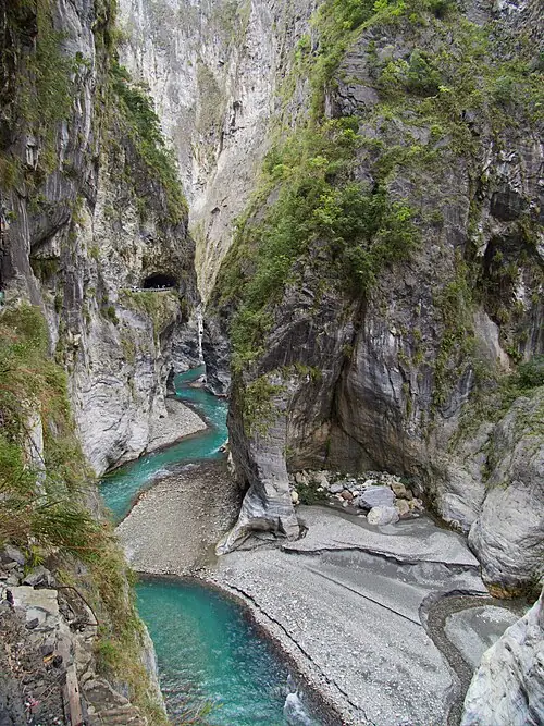 Marble cliffs and river in Taroko Gorge, photographed in March 2024 · 2024年3月拍摄的太鲁阁峡谷岩壁与河道 Source-recorded photograph date: 2025-07-26 18:47:07.
Taroko National Park太鲁阁国家公园
Taroko National Park is defined by marble cliffs, the Liwu River and the steep mountain landscape behind Taiwan’s east coast. Earthquake damage has changed how visitors can experience the gorge. The current park guidance lists…
Read the place guide →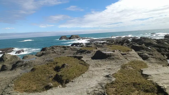 Eroded coastal potholes at Shitiping in Hualien · 花莲石梯坪海岸壶穴地形 Source-recorded photograph date: 2018-11-03 10:18:06.
Shitiping Coastal Terraces石梯坪
Shitiping (石梯坪) is a rocky coastal landscape in Fengbin Township, where pale volcanic rock forms broad, step-like surfaces beside the Pacific.
Read the place guide →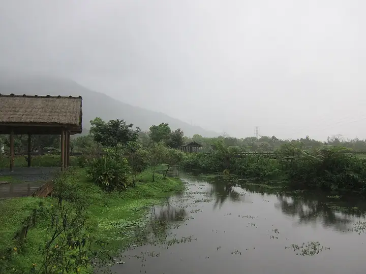 Water and vegetation at Matai'an Wetland in Guangfu · 光复马太鞍湿地的水面与植被 Source-recorded photograph date: 2012-02-25.
Mataian Wetland马太鞍湿地
Mataian Wetland (马太鞍湿地) is a spring-fed inland wetland beside the Amis community in Guangfu Township.
Read the place guide →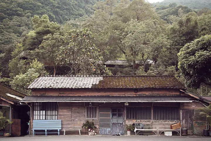 A former forestry-settlement timber house at Lintianshan · 林田山林业聚落的木造房屋 Source-recorded photograph date: 2019-05-19 15:44:46.
Lintianshan Forestry Culture Park林田山林业文化园区
Lintianshan Forestry Culture Park (林田山林业文化园区) preserves a former logging settlement in Fenglin Township.
Read the place guide →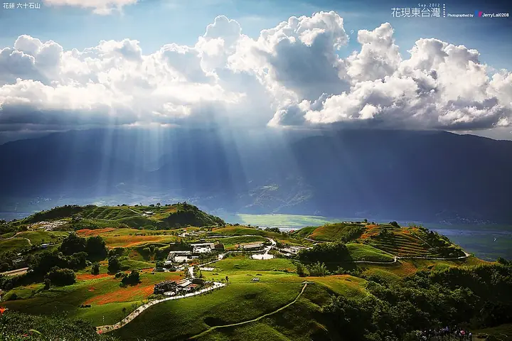 Hillside fields on Liushidan Mountain in Fuli, Hualien · 花莲富里六十石山的山坡田野 Source-recorded photograph date: Taken on 14 July 2012, 15:48.
Liushishi Mountain Daylily Fields六十石山
Liushishi Mountain (六十石山) is a cultivated upland landscape east of Zhutian village in Fuli Township, on the western side of the Coastal Range.
Read the place guide → Liyu Lake and a small landing stage in Hualien · 花莲鲤鱼潭与小码头 Source-recorded photograph date: 2009-11-14.
Liyu Lake, Hualien鲤鱼潭
Liyu Lake (鲤鱼潭) in Hualien is the elongated inland lake below Liyu Mountain at Chinan in Shoufeng Township.
Read the place guide →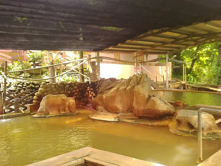 A bathing pool at Ruisui Hot Springs · 瑞穗温泉的一处浴池 Source-recorded photograph date: 2018-08-15.
Ruisui Hot Springs瑞穗温泉
Ruisui Hot Springs (瑞穗温泉) are part of the geothermal landscape around Ruisui in the East Rift Valley.
Read the place guide →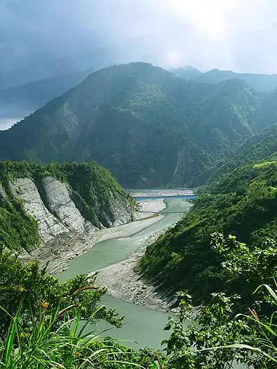 The Xiuguluan River winding through its Hualien valley · 秀姑峦溪流经花莲山谷 Source-recorded photograph date: 2006-02-10.
Xiuguluan River Guided Rafting秀姑峦溪正规漂流
The Xiuguluan River (秀姑峦溪) crosses eastern Taiwan's mountain landscape from the Central Range through the Coastal Range to the Pacific.
Read the place guide →Taroko Gorge in March 2024, before the April 2024 earthquake · 2024年3月的太鲁阁峡谷,摄于同年4月地震前 Source-recorded photograph date: 2025-07-26 18:47:07.Taroko National Park — Access Check Required太鲁阁国家公园(开放范围专项核实)
Taroko National Park (太鲁阁国家公园) protects a dramatic transition from eastern Taiwan's marble gorge to high mountain country.
Read the place guide →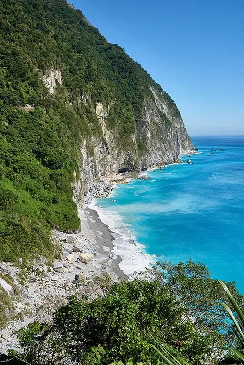 Qingshui Cliff and the Pacific coast in December 2018 · 2018年12月的清水断崖与太平洋海岸 Source-recorded photograph date: 2018-12-03 11:24:06.
Qingshui Cliffs — Viewpoint Access Check清水断崖(观景平台专项核实)
Qingshui Cliffs (清水断崖) form the abrupt meeting of mountains and the Pacific along the Suhua coast in Xiulin Township.
Read the place guide →Local life & food
Hualien County local specialties
花蓮縣特色美食 · 11 specialties to discover
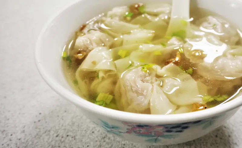 Bianshi Wontons 扁食
Bianshi Wontons (扁食) refer to the thin-skinned filled dumplings called bianshi in Taiwan (臺灣) and southern Fujian (福建). Yuli (玉里), in Hualien County (花蓮縣), is one of the island's noted places for wontons.
Read the dish guide →Photo adjustments
EXIF orientation normalized; resized without changing aspect ratio; converted to WebP. No subject edits.
 Gongzheng Steamed Buns 公正包子Reference photo of a similar dish · 同类菜品参考照片
Gongzheng Steamed Buns (公正包子) is listed among the local specialties of Hualien County, Taiwan. The term 包子 points to steamed buns.
Read the dish guide →
Photo adjustments
Full frame retained; EXIF orientation normalized, proportionally resized to at most 800 pixels and converted to WebP. No generated pixels or subject changes. Cards may crop the display.
 Bomb Scallion Pancake 炸弹葱油饼AI illustration · AI 示意图(仅供参考,非实拍)
Bomb Scallion Pancake (炸弹葱油饼) is listed among the local specialties of Hualien County, Taiwan. The term 饼 points to cakes or flatbreads. 炸 describes frying.
Read the dish guide →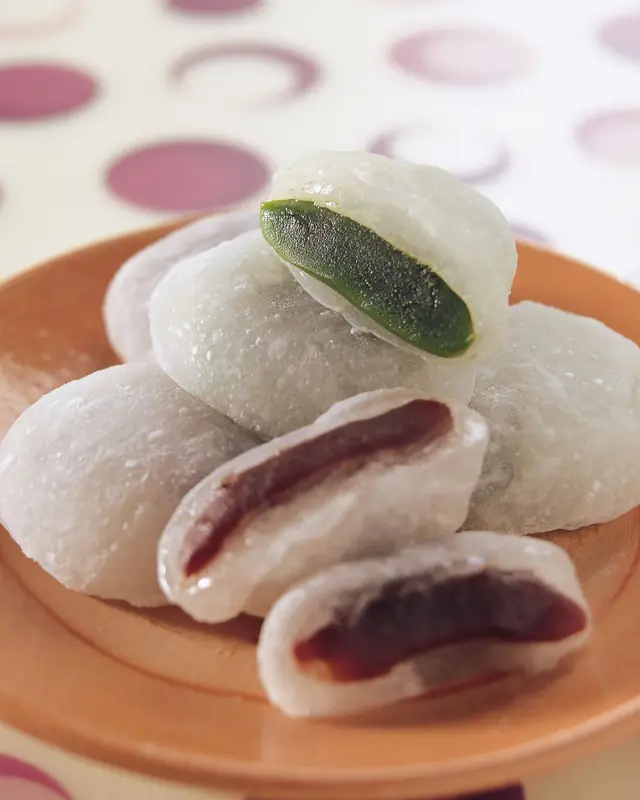 Mochi Rice Cakes 麻糬
Mochi Rice Cakes (麻糬) are a Hualien (花蓮) specialty with a documented Hakka tradition. The tourism authority highlights the filled cakes associated with the Tzen family (曾姓).
Source ↗Read the dish guide →Photo adjustments
EXIF orientation normalized; resized without changing aspect ratio; converted to WebP. No subject edits.
 Peeled Chili Pepper Chicken Soup 剥皮辣椒鸡汤Reference photo of a similar dish · 同类菜品参考照片
Peeled Chili Pepper Chicken Soup (剥皮辣椒鸡汤) combines preserved green chillies with chicken thigh meat and stock. A Hualien (花蓮) agricultural recipe uses locally grown peppers for an aromatic soup with tender, juicy meat.
Read the dish guide →
Photo adjustments
Full frame retained; EXIF orientation normalized, proportionally resized to at most 800 pixels and converted to WebP. No generated pixels or subject changes. Cards may crop the display.
 Yuli Noodles 玉里面AI illustration · AI 示意图(仅供参考,非实拍)
Yuli Noodles (玉里面) take their name from Yuli (玉里) in Hualien County (花莲县). Originally called Yuli damian (玉里大麵), it combines handmade yellow noodles with a rich pork-bone broth.
Read the dish guide → Hualien Sweet Potato Cakes 花莲薯AI illustration · AI 示意图(仅供参考,非实拍)
Hualien Sweet Potato Cakes (花莲薯) are a sweet specialty of Hualien (花蓮), also known as xianziyu (餡子芋). They are made by processing sweet potatoes into cakes.
Read the dish guide → Indigenous Stone Hot Pot 原住民石头火锅AI illustration · AI 示意图(仅供参考,非实拍)
Indigenous Stone Hot Pot (原住民石头火锅) is the stone hot pot of the Amis people (阿美族) of Hualien (花蓮).
Read the dish guide →All dish names · 全部菜名 (11)
- Bianshi Wontons · 扁食
- Gongzheng Steamed Buns · 公正包子
- Bomb Scallion Pancake · 炸弹葱油饼
- Mochi Rice Cakes · 麻糬
- Peeled Chili Pepper Chicken Soup · 剥皮辣椒鸡汤
- Yuli Noodles · 玉里面
- Hualien Sweet Potato Cakes · 花莲薯
- Indigenous Stone Hot Pot · 原住民石头火锅
- Bamboo Tube Rice · 竹筒饭
- Salt-Baked Tilapia · 盐烤吴郭鱼
- Pork Buns with Peeled Chili Peppers · 剥皮辣椒肉包
More dishes from across Taiwan are in the Taiwan food guide.
Townships, districts & local cities in Hualien County
13 areas belong directly to Hualien County.
13 areas
Hualien City 花蓮市
Hualien is a county-administered city and the county seat of Hualien County, Taiwan. It is located on the east coast of Taiwan on the Pacific Ocean, and has a population of 99,458 inhabitants.
Explore the area →TownshipFenglin Township 鳳林鎮
Fenglin Township, is an urban township in central Hualien County, Taiwan. It is located in Huatung Valley bordering Shoufeng Township on the north and Guangfu Township on the south.
Explore the area →TownshipYuli Township 玉里鎮
Yuli Township, Amis: Posko, Bunun: Pusqu (Hanzi transliterated by 1917: 璞石閣), is an urban township located in central Huadong Valley, and also the southern administrative center of Hualien County, Taiwan.
Explore the area →Rural townshipXincheng Township 新城鄉
Xincheng Township or Sincheng Township is a rural township located in north of Hualien County, Taiwan, and has a population of 20,308 inhabitants and 8 villages.
Explore the area →Show fewer areas
Ji'an Township 吉安鄉
Ji'an Township, is a rural township in Hualien County, Taiwan. It has 18 villages and a population of 83,750 inhabitants.
Explore the area →Rural townshipShoufeng Township 壽豐鄉
Shoufeng Township is a rural Township in Hualien County, Taiwan. The township sits in the north segment of East Rift Valley between Taiwan's Central Range and Coastal Mountain Range near the Pacific Ocean.
Explore the area →Rural townshipGuangfu Township 光復鄉
Guangfu Township is a rural township located in the mid-Huatung Valley of Hualien County, Taiwan. The indigenous Amis people make up about half of the population. The main economic activity is agriculture.
Explore the area →Rural townshipFengbin Township 豐濱鄉
Fengbin Township is a rural township located in Hualien County, Taiwan, bordering Taitung County. The Pacific Ocean lies to the east and the Hai'an Range to the west.
Explore the area →Rural townshipRuisui Township 瑞穗鄉
Ruisui Township is a rural township located in southern Hualien County, Taiwan, and has a population of 10,944 inhabitants in 11 villages.
Explore the area →Rural townshipFuli Township 富里鄉
Fuli Township is a rural township located in southern Hualien County, Taiwan.
Explore the area →Rural townshipXiulin Township 秀林鄉
Xiulin Township / Sioulin Township is a mountain indigenous township of Hualien County, Taiwan. It is located northwest of Hualien City, and is the largest township in Taiwan by area (1,641.86 km²) with 9…
Explore the area →Rural townshipWanrong Township 萬榮鄉
Wanrong Township or Wanrung Township is a mountain indigenous township located in the west of Hualien County, Taiwan, and has a population of 6,154 inhabitants and 8 villages.
Explore the area →Rural townshipZhuoxi Township 卓溪鄉
Zhuoxi Township is a mountain indigenous township in Hualien County, Taiwan, bisected by the Tropic of Cancer. It lies on the Central Mountain Range (up to 95% of its area) with steep mountains which makes it…
Explore the area →No areas match this name.
Plan your visit
Getting there
Search for 花蓮縣 in a map app to find stations and your accommodation.
Where to stay →Build your route
Hualien and Qixingtan Beach are about 7 km apart in a straight line. The linked place guides have entrance and visit details.
Continue with Taiwan →More in Taiwan
Sources & geographic information
Administrative names and parent areas: Official geographic directory · Reference date 2026-09-06.
Background text adapted from Hualien County — Wikipedia contributors, under CC BY-SA 4.0. Text has been shortened and reorganized; source revision 1366855713.
Photo: Hualien · Mfpan9389115 · CC BY-SA 4.0. Full-frame source proportionally resized and converted to WebP for display. No subject alteration. Source-supplied marks and edits remain; cards may crop the view.

Photo: Qixingtan Beach · Fred Hsu (Wikipedia:User:Fred Hsu on en.wikipedia) · CC BY-SA 3.0. Full-frame source proportionally resized and converted to WebP for display. No subject alteration. Source-supplied marks and edits remain; cards may crop the view.

Photo: Taroko National Park · lumoplank · CC0. Full-frame source proportionally resized and converted to WebP for display. No subject alteration. Source-supplied marks and edits remain; cards may crop the view.

Photo: Shitiping Coastal Terraces · Thouyutim · CC BY-SA 4.0. Full-frame source proportionally resized and converted to WebP for display. No subject alteration. Source-supplied marks and edits remain; cards may crop the view.

Photo: Mataian Wetland · Bellenion · CC BY-SA 3.0. Full-frame source proportionally resized and converted to WebP for display. No subject alteration. Source-supplied marks and edits remain; cards may crop the view.

Photo: Lintianshan Forestry Culture Park · 張雅倫 · CC BY-SA 4.0. Full-frame source proportionally resized and converted to WebP for display. No subject alteration. Source-supplied marks and edits remain; cards may crop the view.
%E6%9E%97%E6%A5%AD%E8%81%9A%E8%90%BD.jpg)
Photo: Liushishi Mountain Daylily Fields · Jerry Lai from Hsinchu, Taiwan · CC BY-SA 2.0. Full-frame source proportionally resized and converted to WebP for display. No subject alteration. Source-supplied marks and edits remain; cards may crop the view.

Photo: Liyu Lake, Hualien · Fred Hsu (Wikipedia:User:Fred Hsu on en.wikipedia) · CC BY-SA 3.0. Full-frame source proportionally resized and converted to WebP for display. No subject alteration. Source-supplied marks and edits remain; cards may crop the view.

Photo: Ruisui Hot Springs · Kamakura · CC BY-SA 4.0. Full-frame source proportionally resized and converted to WebP for display. No subject alteration. Source-supplied marks and edits remain; cards may crop the view.

Photo: Xiuguluan River Guided Rafting · Prattflora · CC BY-SA 3.0. Full-frame source proportionally resized and converted to WebP for display. No subject alteration. Source-supplied marks and edits remain; cards may crop the view.

Photo: Taroko National Park — Access Check Required · lumoplank · CC0. Full-frame source proportionally resized and converted to WebP for display. No subject alteration. Source-supplied marks and edits remain; cards may crop the view.
Photo: Qingshui Cliffs — Viewpoint Access Check · mk_is_here · CC BY 2.0. Full-frame source proportionally resized and converted to WebP for display. No subject alteration. Source-supplied marks and edits remain; cards may crop the view.

Map data © OpenStreetMap contributors. Pins mark approximate centres, not entrances or boundaries.