


Get to know Ruifang District
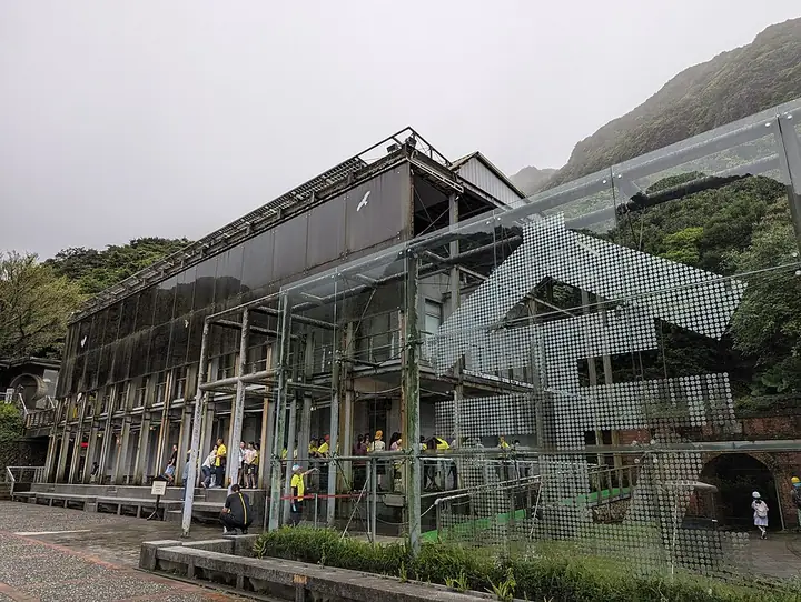
Photo adjustments
Full-frame source proportionally resized and converted to WebP for display. No subject alteration. Source-supplied marks and edits remain; cards may crop the view.
- Administrative area
- District · 區
- Part of
- New Taipei City
- Chinese name
- 瑞芳區
- Local areas
- District guide
Area & population
- Area in the source
- 70.73 km²
Source: cited geographic source, as of the dates shown.
Setting and landscape
Hills surround the district on three sides and the sea lies on the fourth; apart from a narrow coastal strip and river terraces, almost all of it is hillside, part of the Keelung Hills (基隆丘陵) at the northern tip of the Central Mountain Range. The Keelung River runs about 20 kilometres through the district in an L-shaped course, turning from north-east to north near Sandiaoling (三貂嶺) and then east near Ganzilai (柑子瀨).
History
The name comes from a general store called Ruifang (瑞芳) near the Keelung River ferry at Ganzilai, where gold prospectors and travellers to Kavalan (噶瑪蘭, today's Yilan) stopped for supplies; people spoke of "going to Ruifang". According to the Gold Museum, the gold rush began in 1890, when Cantonese railway workers building a bridge on the Qidu (七堵) section found gold dust in the Keelung River. An outcrop was found on the hill of Jiufen in 1893, and in 1894 prospectors named Jinguashi, "golden melon stone", after a large outcrop. In 1933 a new flotation plant was built at Shuinandong (水湳洞) on the coast. During the Pacific War the Japanese army ran a prisoner-of-war camp at Jinguashi and made more than 500 Allied prisoners, mostly from the British Commonwealth, mine copper. Gold mining at Jiufen ended in 1971, and the Taiwan Metal Mining Company (臺金公司) closed in 1987, ending almost a century of gold mining at Jinguashi.
What to see
The Gold Museum (黃金博物館) opened at Jinguashi in 2004 as an eco-museum that keeps the area's mine sites, buildings and natural setting together. In Jiufen, the Shengping Theater (昇平戲院) was built in the Showa era as a stone-and-timber house with a revolving stage; it closed as mining declined, lost its roof to a typhoon in 1994, and reopened in 2011 after repairs that restored its 1960s interior. Houtong (猴硐) had coal mines owned by Taiyang Mining (臺陽礦業), the company that also held the Jiufen gold mine.
Highlights
- Gold Museum 黃金博物館: Eco-museum at Jinguashi, opened in 2004, preserving mine sites and buildings.
- Shengping Theater 昇平戲院: Jiufen's old theatre, rebuilt after typhoon damage and reopened in 2011.
- Jiufen 九份: Hill town where a gold outcrop was found in 1893; gold mining there ended in 1971.
- Houtong 猴硐: Former coal-mining area whose mines belonged to Taiyang Mining.
Sources for this guide
瑞芳区 - 维基百科,自由的百科全书 · Chinese Wikipedia · CC BY-SA 4.0
簡介 | 新北市立黃金博物館 · New Taipei City Gold Museum
歷史沿革 | 新北市立黃金博物館 · New Taipei City Gold Museum
Original English written from the listed sources and checked sentence by sentence against quoted extracts by a separate reviewer. Updated 2026-09-25.
Explore Ruifang District
Core places to explore, with English and Chinese names.
Places to explore around Ruifang District
 A shop-lined lane on Jiufen Old Street · 九份老街两侧商铺与巷道 Source-recorded photograph date: 2024-11-28 08:27:06.
Jiufen九份
Jiufen grew with gold mining before its hillside streets found a new life through tourism and cinema. The old settlement sits between mountain and sea, with steep changes of level, close-packed buildings and tea houses that…
Read the place guide →Gold Building at the Gold Museum in Jinguashi · 金瓜石黄金博物馆黄金馆 Source-recorded photograph date: 2025-07-19 14:42:44.Jinguashi and the Gold Museum金瓜石与黄金博物馆
The Gold Museum occupies part of Jinguashi's former mining landscape in Ruifang.
Read the place guide →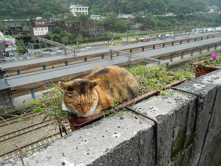 A cat beside the railway-station viewpoint in Houtong · 猴硐车站旁眺望点的猫咪 Source-recorded photograph date: 2013-12-08 14:25:52.
Houtong Cat Village and Mining Heritage猴硐猫村
Houtong in Ruifang is widely known for cats around its railway settlement, but its built landscape also records an earlier coal-mining economy.
Read the place guide →Plan your visit
Getting there
Ruifang District is about 35 km in a straight line from central New Taipei City. Search for 瑞芳區 in a map app to find stations and your accommodation.
Where to stay →Build your route
Jiufen and Jinguashi and the Gold Museum are both listed here. The linked place guides have entrance and visit details.
Continue with New Taipei City →More in New Taipei City
Sources & geographic information
Administrative names and parent areas: Official geographic directory · Reference date 2026-09-06.
Some facts checked against 瑞芳区 — Wikipedia contributors, CC BY-SA 4.0.
Photo: Jiufen · Another Believer · CC BY-SA 4.0. Full-frame source proportionally resized and converted to WebP for display. No subject alteration. Source-supplied marks and edits remain; cards may crop the view.

Photo: Jinguashi and the Gold Museum · 人人生來平等 · CC BY-SA 4.0. Full-frame source proportionally resized and converted to WebP for display. No subject alteration. Source-supplied marks and edits remain; cards may crop the view.

Photo: Houtong Cat Village and Mining Heritage · P1340 · CC BY-SA 3.0. Full-frame source proportionally resized and converted to WebP for display. No subject alteration. Source-supplied marks and edits remain; cards may crop the view.

Map data © OpenStreetMap contributors. Pins mark approximate centres, not entrances or boundaries.