


Get to know Qamdo

Photo adjustments
Full frame retained; proportionally resized and converted to WebP. No retouching or changes to the photographed subject. Card displays may crop the view.
- Administrative area
- Prefecture-level city · 地级市
- Part of
- Tibet (Xizang)
- Chinese name
- 昌都市
- Local areas
- 11 local areas
Area & population
- Area in the source
- 110,154.00 km²
- Population · 2019
- 798,067
- Administrative seat
- Karub District (Chengguan)
Source: cited geographic source, as of the dates shown.
Chamdo is divided into 11 county-level divisions: one district and ten counties. The main district is Karuo District. Other counties include Jonda County, Gonjo County, Riwoche County, Dengqen County, Zhag'yab County, Baxoi County, Zognang County, Maarkam County, Lhorong County, and Banbar County.
Transportation
From 1951 to 1954, the Chinese army constructed a 2,300 kilometre long highway from Ya'an to Lhasa that went through Chamdo.
Entry & permits for Tibet (Xizang)
Foreign tourists need Tibet entry approval, commonly called a Tibet Travel Permit, and an organised visit arranged through a specialist travel agency in China. Confirm your approved route before booking transport. Requirements differ for Taiwan residents and for travellers using mainland or Hong Kong/Macao Chinese resident documents; check the document guide before you book.
Check the travel-document requirements →Policy scope verified: 2026-09-06. UK FCDO: China regional travel advice ↗ State Council Taiwan Affairs Office: Tibet entry approval ↗ Xizang Department of Culture and Tourism: Medog border permit notice ↗
Explore Qamdo
Core places to explore, with English and Chinese names.
Galden Jampaling Monastery 强巴林寺
Riwoche Monastery 类乌齐寺
Ranwu Lake 然乌湖
Karuo Archaeological Site 卡若遗址
Zizhu Monastery 孜珠寺
Laigu Glacier Visitor Area 来古冰川开放游览区
Boluo Guze Woodblock Carving Village 波罗古泽木刻村
Chagyama Great Hall 查杰玛大殿
Yanjing Ancient Salt Fields 盐井古盐田
Yanjing Catholic Church 盐井天主教堂
Karuo District 卡若区
Jomda County 江达县
Gonjo County 贡觉县
Riwoqê County 类乌齐县
Dêngqên County 丁青县
Zhag'yab County 察雅县
Baxoi County 八宿县
Zogang County 左贡县
Markam County 芒康县
Lhorong County 洛隆县
Banbar County 边坝县
Places to explore around Qamdo
 Exterior wall and eaves at Galden Jampaling Monastery, Chamdo. Photograph date recorded by the source: 2017-07-31 20:53:20.
Galden Jampaling Monastery强巴林寺
Galden Jampaling stands on the terraces of Mala Hill above central Chamdo, where the city developed around converging rivers. The monastery’s name refers to Maitreya, and its main assembly hall is surrounded by colleges, chapels…
Read the place guide →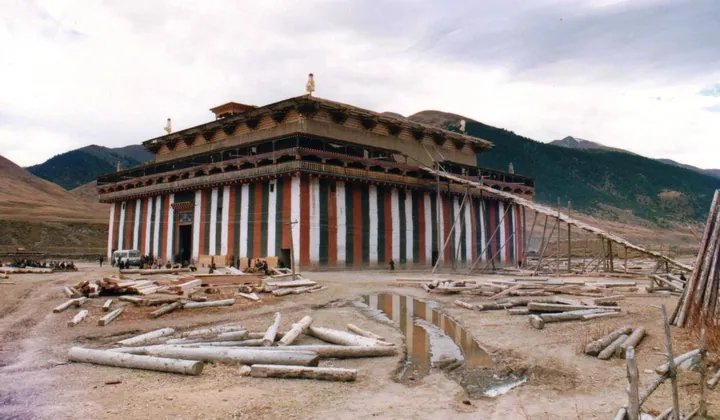 Exterior of Riwoche Monastery in Qamdo, Tibet Autonomous Region · 西藏昌都市类乌齐寺外观 Source-recorded photograph date: 1988.
Riwoche Monastery类乌齐寺
Riwoche Monastery, also called Yanggon, is dominated by the Chajema hall in Riwoche town. Its lower walls carry striking red, white and black vertical stripes, while the upper red and white storeys step inward beneath a golden…
Read the place guide → Ranwu Lake below snow-covered mountains. Photograph date recorded by the source: 2013-05-25 12:05:46.
Ranwu Lake然乌湖
Ranwu Lake occupies a landslide-dammed basin beside the road corridor through Baxoi. It feeds the Parlung River and is framed by mountains and glacier country, but its accessible shores also include fields, grazing animals and…
Read the place guide → Karuo Archaeological Site · 卡若遗址
Karuo Archaeological Site卡若遗址
Karuo preserves the evidence of a prehistoric settlement in the upper Lancang valley. Excavations revealed house foundations, stone and bone tools, pottery and traces of millet cultivation and pig keeping. The changing house…
Read the place guide →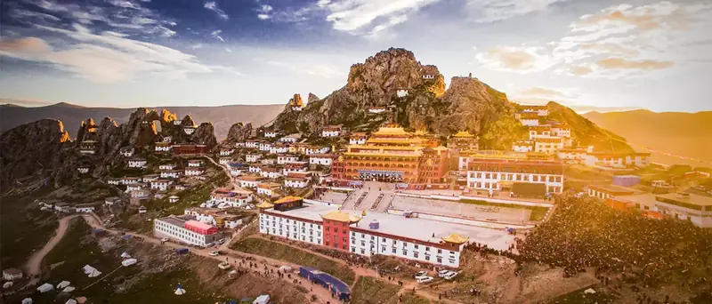 Zizhu Monastery · 孜珠寺
Zizhu Monastery孜珠寺
Bon monastery at about 4,850 m below the six peaks of Zizhu Mountain in Dengqen County, Chamdo, with meditation caves and a twelve-yearly masked dance.
Read the place guide → Laigu Glacier Visitor Area · 来古冰川开放游览区
Laigu Glacier Visitor Area来古冰川开放游览区
Laigu (来古冰川) is a group of glaciers in 然乌镇 in Baxoi County, Chamdo, Tibet, at the head of the Parlung Tsangpo and immediately beside 然乌湖, named after the village at its foot.
Read the place guide →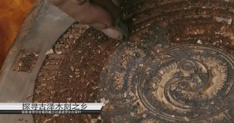 Boluo Guze Woodblock Carving Village · 波罗古泽木刻村
Boluo Guze Woodblock Carving Village波罗古泽木刻村
Bolo Guze (波罗古泽) is the woodblock-carving craft of 波罗乡 in Jomda (江达) County, Chamdo, Tibet, and the 木刻村 the catalogue names is its main production village, 外冲村.
Read the place guide →The main hall of Riwoche (Leiwuqi) Monastery, known in Tibetan as Chajema, in Leiwuqi County, Chamdo · 类乌齐寺(查杰玛大殿)主殿外观,西藏昌都市类乌齐县 Source-recorded photograph date: 1988.Chagyama Great Hall查杰玛大殿
Chagyama Great Hall (查杰玛大殿) is the main building of Riwoche Monastery in Riwoche County, Qamdo, in the Tibet Autonomous Region, and is a national-level protected cultural relics unit. The reports carried by the regional culture-and-tourism department call the monastery the ancestral monastery of the Taklung Kagyu school in eastern Tibet.
Read the place guide →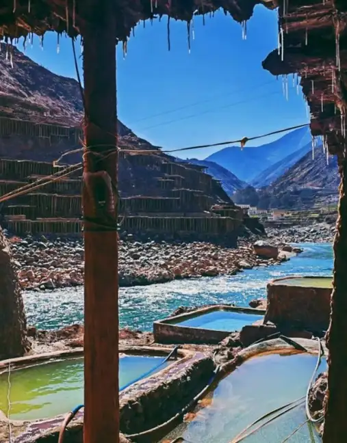 Yanjing Ancient Salt Fields · 盐井古盐田
Yanjing Ancient Salt Fields盐井古盐田
The old salt fields of Yanjing (盐井古盐田) are tiers of timber-framed evaporation pans on the cliffs of the Lancang (Mekong) gorge in Markam County, Qamdo, in the Tibet Autonomous Region, where brine is drawn from wells beside the river and dried in the sun. The name is 察卡洛 in Tibetan, in which 察 means edible salt and 卡 a hole or eye.
Read the place guide → Yanjing Catholic Church · 盐井天主教堂
Yanjing Catholic Church盐井天主教堂
Yanjing Catholic Church (盐井天主教堂) stands at Shangyanjing village in Naxi Township, Markam County, Qamdo, in the Tibet Autonomous Region, beside National Highway 214. Both the county government and the Qamdo municipal tourism bureau describe it as the only Catholic church in Tibet, and both give its site as about 6,008 square metres.
Read the place guide →Local life & food
Qamdo local specialties
昌都市特色美食 · 10 specialties to discover
 Qamdo Jiajia Noodles 昌都加加面AI illustration · AI 示意图(仅供参考,非实拍)
Qamdo Jiajia Noodles (昌都加加面) take their name from repeated additions to a small bowl. Its Yanjing (盐井) tradition belongs to Naxi Ethnic Township (纳西民族乡), in Markam County (芒康县), Qamdo (昌都).
Read the dish guide → Yak Meat Soup Hot Pot 牦牛肉汤锅AI illustration · AI 示意图(仅供参考,非实拍)
Yak Meat Soup Hot Pot (牦牛肉汤锅) is listed among the local specialties of Qamdo, Tibet (Xizang). The name includes 牛肉 (beef). The term 汤 points to soup.
Read the dish guide →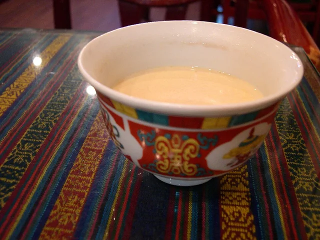 Butter tea 酥油茶
The flavor is savory, tea-bitter and rich, with a smooth fatty mouthfeel rather than the sweetness of commercial milk tea.
Source ↗Read the dish guide →
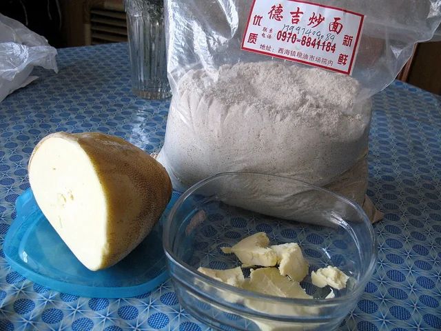 Tsampa 糌粑
The flavor is distinctly toasted and grainy, with richness from butter and a texture that changes with added liquid. It is substantial rather than a light powder garnish.
Source ↗Read the dish guide →
Photo adjustments
EXIF orientation applied where present; resized proportionally to at most 640 px on the long edge and encoded as WebP. No crop, retouching, recoloring or subject changes.
 Tibetan Blood Sausage 藏式血肠
Tibetan Blood Sausage (藏式血肠) is a traditional Lhasa (拉萨) dish made by filling an animal-intestine casing with blood and other ingredients.
Read the dish guide →Photo adjustments
EXIF orientation normalized; resized without changing aspect ratio; converted to WebP. No subject edits.
 Wind-Dried Beef 风干牛肉AI illustration · AI 示意图(仅供参考,非实拍)
Wind-Dried Beef (风干牛肉) in Changdu (昌都) includes a distinctive yak-meat preparation dried as whole legs.
Read the dish guide →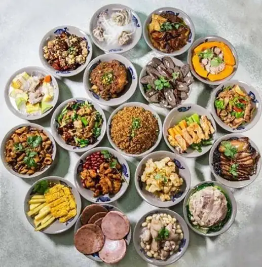 Tibetan Fragrant Pig 藏香猪
Tibetan Fragrant Pig (藏香猪) is the pork of the Tibetan pig, a local Chinese breed that farmers in Qamdo (昌都), Tibet, raise and cure. Zogang County (左贡县) and Baxoi County (八宿县), both in Qamdo, have Tibetan pig industries.
Read the dish guide →Photo adjustments
EXIF orientation normalized; resized without changing aspect ratio; converted to WebP. No subject edits.
 Highland-barley flatbread 青稞饼AI illustration · AI 示意图
The bread has a rustic grain aroma, dense crumb and firmer crust. Added fat or sweetening can make individual versions quite different.
Source ↗Read the dish guide →More dishes from across Tibet (Xizang) are in the Tibet (Xizang) food guide.
Counties & districts in Qamdo
11 areas belong directly to Qamdo.
11 areas
Karuo District 卡若区
Karub District also known as Kharro or Karuo, is a district in Qamdo, in the Tibet Autonomous Region of China, and the seat of government of Qamdo.
Explore the area →CountyJomda County 江达县
Jomda County (Tibetan: འཇོ་མདའ་རྫོང་; Chinese: 江达县) is a county in Chamdo of the Tibet Autonomous Region, China.
Explore the area →CountyGonjo County 贡觉县
Gonjo County (Tibetan: གོ་འཇོ་རྫོང་; Chinese: 贡觉县) is a county of the Chamdo Prefecture in the east of the Tibet Autonomous Region, China, bordering Sichuan province to the east.
Explore the area →CountyRiwoqê County 类乌齐县
Riwoche (Tibetan: རི་བོ་ཆེ་རྫོང་།; Chinese: 类乌齐县) is a county under the administration of the prefecture-level city of Chamdo in the Tibet Autonomous Region, China.
Explore the area →Show fewer areas
Dêngqên County 丁青县
Dêngqên County (Tibetan: སྟེང་ཆེན་རྫོང་།; Chinese: 丁青县) is a county of Chamdo City in the east of the Tibet Autonomous Region, China.
Explore the area →CountyZhag'yab County 察雅县
Zhag'yab County (Tibetan: བྲག་གཡབ་རྫོང, Wylie: brag g.yab rdzong, THL: drak yap dzong; Chinese: 察雅县; pinyin: Chá yǎ xiàn), also spelled Dragyab, Chagyab, Draya, and Chaya, is a county of the Chamdo Prefecture…
Explore the area →CountyBaxoi County 八宿县
Pasho County or Baxoi County (Tibetan: དཔའ་ཤོད་རྫོང་།; simplified Chinese: 八宿县; traditional Chinese: 八宿縣; pinyin: Bāsù Xiàn) is a county under the administration of the prefecture-level city of Chamdo in the…
Explore the area →CountyZogang County 左贡县
Zogong County (Tibetan: མཛོ་སྒང་རྫོང་; Chinese: 左贡县) is a county of the Chamdo Prefecture in the Tibet Autonomous Region, China.
Explore the area →CountyMarkam County 芒康县
Markam or Markham County (Tibetan: སྨར་ཁམས་རྫོང་།; Chinese: 芒康县) is a county under the jurisdiction of Chamdo in the Tibet Autonomous Region, China, bordering the provinces of Sichuan to the east and Yunnan…
Explore the area →CountyLhorong County 洛隆县
Lhorong County (Tibetan: ལྷོ་རོང་རྫོང་།, Chinese: 洛隆县) is a county of Chamdo in the Tibet Autonomous Region, China. The county covers an area of 8,108 km² (3,131 sq mi) and has a population of around 40,000…
Explore the area →CountyBanbar County 边坝县
Banbar County (Tibetan: དཔལ་འབར་རྫོང་།; Chinese: 边坝县) is a county of the Chamdo in the Tibet Autonomous Region, China. The seat is the town of Coka.
Explore the area →No areas match this name.
Plan your visit
Getting there
Search for 昌都市 in a map app to find stations and your accommodation.
Where to stay →Build your route
Galden Jampaling Monastery and Riwoche Monastery are about 70 km apart in a straight line. The linked place guides have entrance and visit details.
Continue with Tibet (Xizang) →More in Tibet (Xizang)
Sources & geographic information
Administrative names and parent areas: Official geographic directory · Reference date 2026-09-06.
Background text adapted from Chamdo — Wikipedia contributors, under CC BY-SA 4.0. Text has been shortened and reorganized; source revision 1338669379.
Photo: Galden Jampaling Monastery · geoff leng · CC0. Full frame retained; proportionally resized and converted to WebP. No retouching or changes to the photographed subject. Card displays may crop the view.

Photo: Riwoche Monastery · MacPraughan · CC BY-SA 3.0. Full frame retained; proportionally resized and converted to WebP. No retouching or changes to the photographed subject. Card displays may crop the view.

Photo: Ranwu Lake · 邢 福君 · CC BY-SA 2.0. Full frame retained; proportionally resized and converted to WebP. No retouching or changes to the photographed subject. Card displays may crop the view.
.jpg)
Photo: Karuo Archaeological Site · Source photographer · License not provided. EXIF orientation normalized; resized without changing aspect ratio; converted to WebP. No subject edits.
Photo: Zizhu Monastery · Source photographer · License not provided. EXIF orientation normalized; resized without changing aspect ratio; converted to WebP. No subject edits.
Photo: Laigu Glacier Visitor Area · Source photographer · License not provided. EXIF orientation normalized; resized without changing aspect ratio; converted to WebP. No subject edits.
Photo: Boluo Guze Woodblock Carving Village · Source photographer · License not provided. EXIF orientation normalized; resized without changing aspect ratio; converted to WebP. No subject edits.
Photo: Chagyama Great Hall · MacPraughan · CC BY-SA 3.0. Full frame retained; proportionally resized and converted to WebP. No retouching or changes to the photographed subject. Card displays may crop the view.
Photo: Yanjing Ancient Salt Fields · Source photographer · License not provided. EXIF orientation normalized; resized without changing aspect ratio; converted to WebP. No subject edits.
Photo: Yanjing Catholic Church · China News Service · CC BY 4.0. EXIF orientation normalized; resized without changing aspect ratio; converted to WebP. No subject edits.

Map data © OpenStreetMap contributors. Pins mark approximate centres, not entrances or boundaries.