


Get to know Kashgar
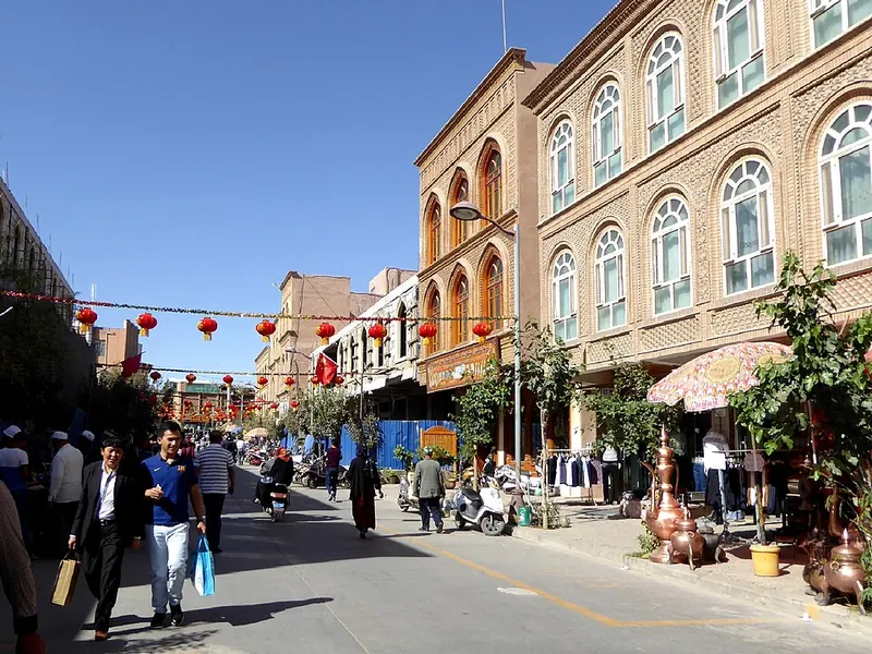
Photo adjustments
Full frame retained; proportionally resized and converted to WebP. No retouching or changes to the photographed subject. Card displays may crop the view.
- Administrative area
- County-level city · 县级市
- Part of
- Kashgar Prefecture
- Chinese name
- 喀什市
- Local areas
- County-level city guide
Area & population
- Area in the source
- 1,056.80 km²
- Population · 2020
- 782,662
- Administrative seat
- Östeng Boyi Subdistrict
Source: cited geographic source, as of the dates shown.
Setting and landscape
The Kunlun range (昆仑山) rises to the south and the southern ranges of the Tianshan (天山) to the north, and the Kashgar River (喀什噶尔河) runs through its flat land. The climate is typical temperate desert. Oasis farming produces peaches, grapes, apricots, pomegranates, cherries, melons, almonds and pistachios.
History
In AD 73 the Han general Ban Chao (班超) installed a new king of Shule, and he then used it as his base in the struggle with the northern Xiongnu for the Western Regions. Under the Tang it became one of the Four Garrisons of Anxi (安西四镇). The Kara-Khanid khanate (喀喇汗国) moved its capital here in 893, and after its khan Satuq Bughra Khan (萨图克·博格拉汗) converted to Islam in 915 the city gradually became Muslim. The modern city was created in 1952.
What to see
The Kashgar Old City (喀什古城) in the centre is a national 5A scenic area. A renovation covering 8.36 square kilometres repaired its traditional houses one design per household within their original layout, and the city government describes coppersmiths, flower-pot, blacksmith and hat bazaars, handmade instruments, pottery and ironware, and a century-old teahouse on Wusitangboyi Old Street (吾斯塘博依老街) where elderly people play the dutar and rawap. A gate-opening ceremony, a camel-caravan parade and a 'princess chooses a groom' procession are staged for visitors.
Id Kah Mosque (艾提尕尔清真寺), first built in the 15th century, stands in the heart of the city and is one of the largest mosques in Xinjiang. The Afaq Khoja Mausoleum (阿帕克和卓之墓), a 17th-century tiled tomb 5 kilometres northeast of the centre, holds five generations of the Afaq Khoja family; it was once wrongly said to be the tomb of the Fragrant Concubine (香妃). Both are national key cultural relics protection sites. The Sunday Market (中西亚市场) continues a Silk Road trade of more than 2,000 years.
Getting oriented
Kashgar has China's westernmost railway station, reached by the Southern Xinjiang Railway since December 1999; the Kashgar–Hotan Railway continues to Yarkand (莎车) and Hotan (和田).
Highlights
- Kashgar Old City 喀什古城: National 5A scenic area of renovated traditional houses, craft bazaars and teahouses.
- Id Kah Mosque 艾提尕尔清真寺: 15th-century mosque in the city centre, a national key cultural relics protection site.
- Afaq Khoja Mausoleum 阿帕克和卓之墓: 17th-century tiled family tomb, once mistaken for the Fragrant Concubine's tomb.
- Kashgar Sunday Market 中西亚市场: Trading point on the Silk Road for more than 2,000 years.
Sources for this guide
《求是》杂志报道了喀什古城! · Kashgar City People's Government
喀什古城一座活着的博物馆 · Kashgar City People's Government
喀什市 - 维基百科,自由的百科全书 · Wikipedia · CC BY-SA 4.0
Kashgar - Wikipedia · Wikipedia · CC BY-SA 4.0
Original English written from the listed sources and checked sentence by sentence against quoted extracts by a separate reviewer. Updated 2026-09-25.
Explore Kashgar
Core places to explore, with English and Chinese names.
Places to explore around Kashgar
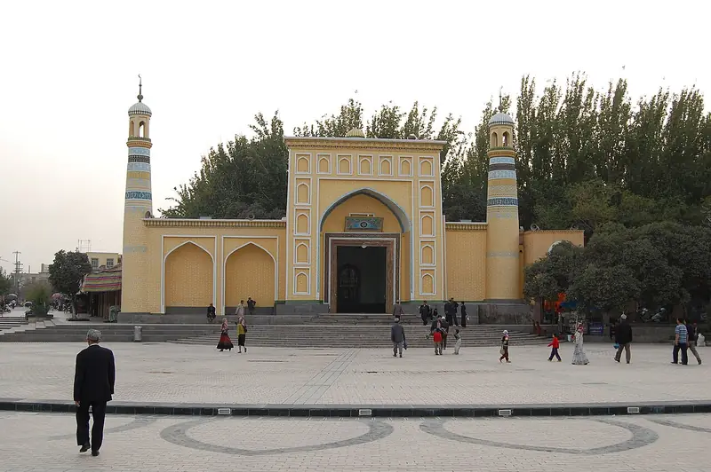 Kashgar Old City (喀什古城景区), Kashgar. Photograph: "Kashgar Id Kah Moschee".
Kashgar Old City喀什古城景区
Kashgar Old City is the historic urban core of Kashgar, with a dense network of lanes and a living Uyghur cultural setting.
Read the place guide →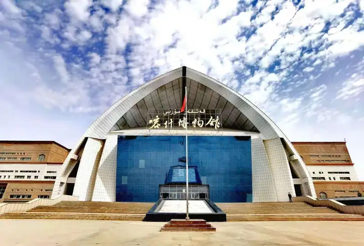 Kashgar Prefecture Museum · 喀什地区博物馆
Kashgar Prefecture Museum喀什地区博物馆
The Kashgar Prefecture Museum (喀什地区博物馆) is a comprehensive history museum in Kashgar city (喀什市), Xinjiang, whose collection runs from the late Palaeolithic to modern times.
Read the place guide →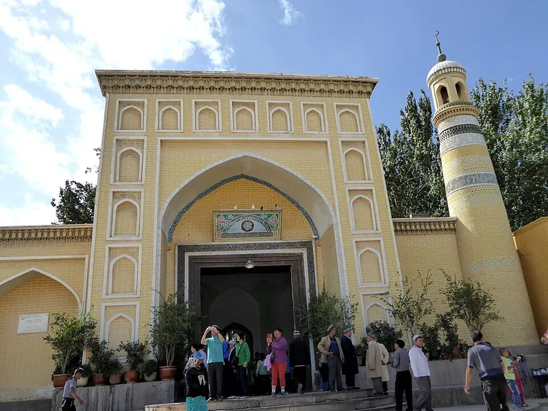 Entrance of Id Kah Mosque in Kashgar. Photograph date recorded by the source: 11 November 2015 (original upload date).
Id Kah Mosque艾提尕尔清真寺
Id Kah Mosque is a major architectural landmark beside Kashgar’s old-city square. Its yellow-toned entrance, flanking towers and deeper courtyard spaces give it a strong presence in the surrounding streets. The complex developed…
Read the place guide →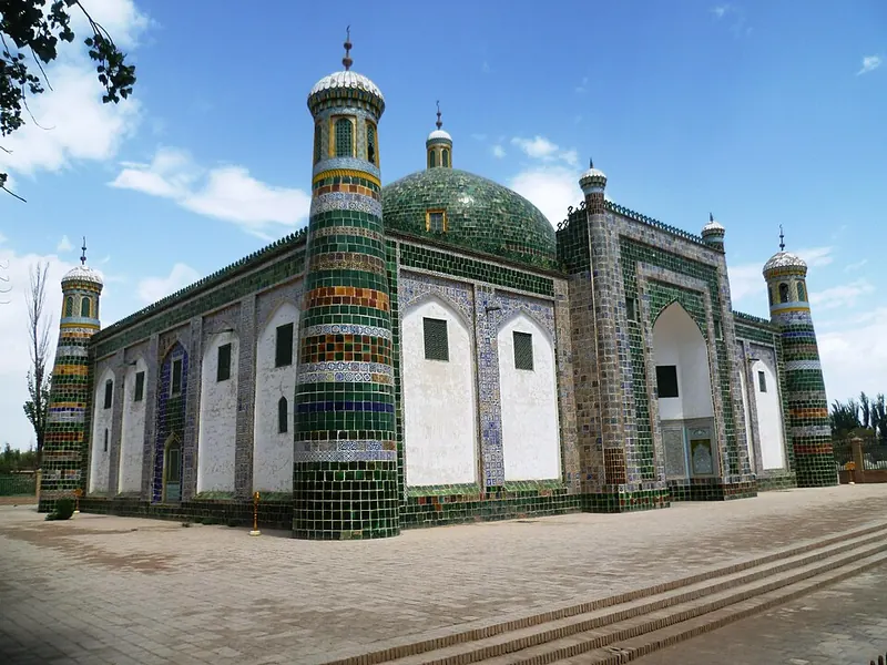 Afaq Khoja Mausoleum in Kashgar. Photograph date recorded by the source: 2017-08-09.
Afaq Khoja Mausoleum香妃园
The Afaq Khoja Mausoleum is a tiled family burial complex northeast of central Kashgar, now within the wider Xiangfei Garden visitor attraction. A large central dome, patterned corner towers and glazed surfaces distinguish the…
Read the place guide →Plan your visit
Getting there
Kashgar covers the centre of Kashgar Prefecture. Search for 喀什市 in a map app to find stations and your accommodation.
Where to stay →Build your route
Kashgar Old City and Kashgar Prefecture Museum are both listed here. The linked place guides have entrance and visit details.
Continue with Kashgar Prefecture →More in Kashgar Prefecture
Sources & geographic information
Administrative names and parent areas: Official geographic directory · Reference date 2026-09-06.
Some facts checked against 喀什市 — Wikipedia contributors, CC BY-SA 4.0.
Some facts checked against Kashgar — Wikipedia contributors, CC BY-SA 4.0.
Photo: Kashgar Old City · See58 · CC BY-SA 3.0. Full frame retained; EXIF orientation normalized, proportionally resized to at most 800 pixels and converted to WebP. No generated pixels or subject changes. Cards may crop the display.

Photo: Kashgar Prefecture Museum · Source photographer · License not provided. EXIF orientation normalized; resized without changing aspect ratio; converted to WebP. No subject edits.
Photo: Id Kah Mosque · Hiroki Ogawa · CC BY 3.0. Full frame retained; proportionally resized and converted to WebP. No retouching or changes to the photographed subject. Card displays may crop the view.
.jpg)
Photo: Afaq Khoja Mausoleum · Radosław Botev · CC BY 3.0 pl. Full frame retained; proportionally resized and converted to WebP. No retouching or changes to the photographed subject. Card displays may crop the view.

Map data © OpenStreetMap contributors. Pins mark approximate centres, not entrances or boundaries.