


Get to know Karamay

Photo adjustments
Full frame retained; proportionally resized and converted to WebP. No retouching or changes to the photographed subject. Card displays may crop the view.
- Administrative area
- Prefecture-level city · 地级市
- Part of
- Xinjiang
- Chinese name
- 克拉玛依市
- Local areas
- 4 local areas
Area & population
- Area in the source
- 7,734.00 km²
- Population · 2020
- 490,348
- Administrative seat
- Karamay District
Source: cited geographic source, as of the dates shown.
Karamay was the site of one of the worst disasters in modern Chinese history, the 1994 Karamay fire, when 324 people, including 288 school children, lost their lives in a cinema fire on 8 December 1994.
Transport
Kuytun–Beitun Railway. There are passenger stations in Karamay itself and in Wuwu New Town (五五新镇街道), south of central Karamay. Karamay–Tacheng Railway Kelamayi Guhai Airport China National Highway 217
Explore Karamay
Core places to explore, with English and Chinese names.
Places to explore around Karamay
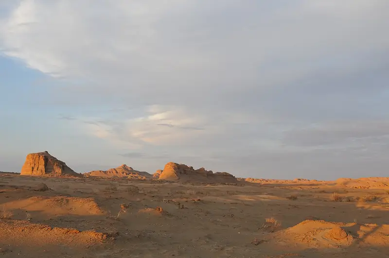 World Devil City · 世界魔鬼城
World Devil City世界魔鬼城
World Devil City (世界魔鬼城), also called Wuerhe Wind City (乌尔禾风城), is a wind-eroded yardang landscape in Wuerhe District (乌尔禾区), Karamay (克拉玛依市), Xinjiang.
Read the place guide →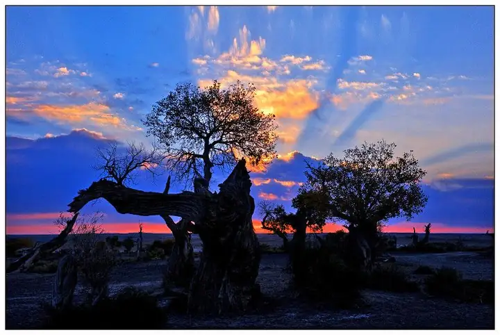 Urho Poplar Forest · 乌尔禾胡杨林
Urho Poplar Forest乌尔禾胡杨林
Wuerhe poplar forest (乌尔禾胡杨林) is the Euphrates poplar woodland of Wuerhe District (乌尔禾区), Karamay (克拉玛依市), Xinjiang, covering 300,000 mu.
Read the place guide → The Karamay Museum building, with its name in gold lettering on the facade · 克拉玛依博物馆建筑外观,正立面金色馆名 Source-recorded photograph date: 2024-09-27 10:09:52.
Karamay Museum克拉玛依博物馆
Karamay's city museum, founded as an oilfield-history hall in 1983, with a BU-40 drilling rig and 1950s drillers' cellars in the yard.
Read the place guide →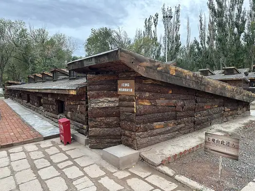 Black Oil Mountain · 黑油山
Black Oil Mountain黑油山
Black Oil Mountain (黑油山) is a group of natural petroleum asphalt mounds two kilometres north-east of the Karamay urban area, in Karamay District (克拉玛依区), Karamay (克拉玛依市), Xinjiang.
Read the place guide → Dushanzi Grand Canyon · 独山子大峡谷
Dushanzi Grand Canyon独山子大峡谷
Dushanzi Grand Canyon (独山子大峡谷) is a canyon in Dushanzi District (独山子区), Karamay (克拉玛依市), Xinjiang, 28 km south of the urban area.
Read the place guide →Local life & food
Karamay local specialties
克拉玛依市特色美食 · 10 specialties to discover
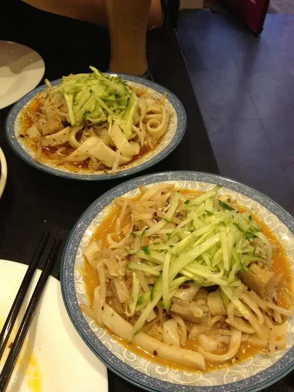 Karamay Cold Noodle Sheets 克拉玛依凉皮Reference photo of a similar dish · 同类菜品参考照片
Karamay Cold Noodle Sheets (克拉玛依凉皮) is a cold wheat-noodle dish from Karamay (克拉玛依), Xinjiang (新疆), distinguished by its seasoned soup.
Read the dish guide →
Photo adjustments
Full frame retained; EXIF orientation normalized, proportionally resized to at most 800 pixels and converted to WebP. No generated pixels or subject changes. Cards may crop the display.
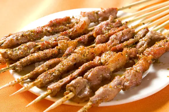 Grilled Lamb 烤羊肉
Grilled Lamb (烤羊肉) is listed among the local specialties of Karamay, Xinjiang. The name includes 羊肉 (lamb or mutton). 烤 describes roasting or grilling.
Read the dish guide →Photo adjustments
EXIF orientation normalized; resized without changing aspect ratio; converted to WebP. No subject edits.
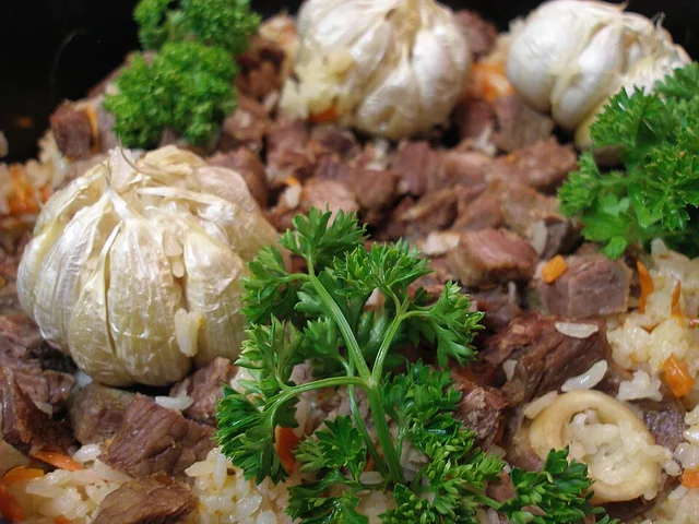 Polo rice 抓饭
The rice is rich and separate-grained, with sweet carrot, savory meat and occasional fruit sweetness rather than a sticky porridge texture.
Source ↗Read the dish guide →
Photo adjustments
EXIF orientation applied where present; resized proportionally to at most 640 px on the long edge and encoded as WebP. No crop, retouching, recoloring or subject changes.
 Hand-Pulled Mixed Noodles 拌面
Hand-Pulled Mixed Noodles (拌面) is listed among the local specialties of Karamay, Xinjiang. The term 面 points to noodles or flour-based food.
Read the dish guide →
Photo adjustments
EXIF orientation normalized; resized without changing aspect ratio; converted to WebP. No subject edits.
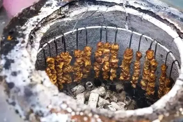 Nang Oven-Roasted Meat 馕坑肉
Nang Oven-Roasted Meat (馕坑肉) is lamb roasted inside a nang oven (馕坑), the oven in which nang flatbread is baked. In Uyghur it is called tonur kawipi, and the dish is also eaten across Central Asia.
Read the dish guide →Photo adjustments
EXIF orientation normalized; resized without changing aspect ratio; converted to WebP. No subject edits.
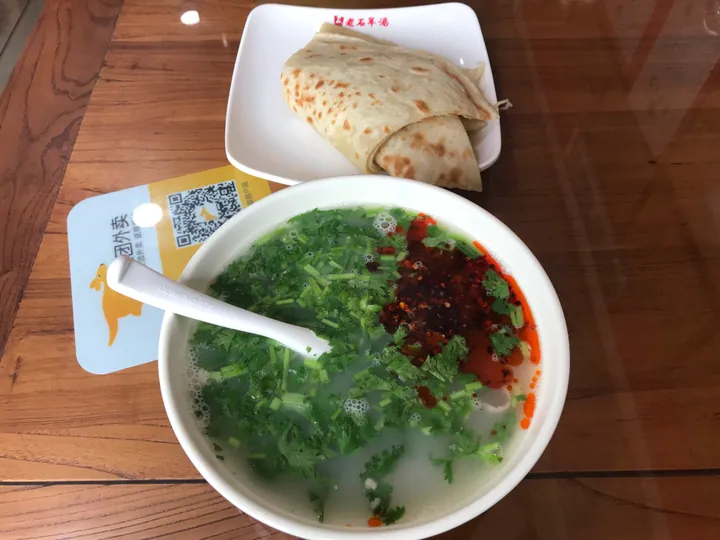 Sheep Offal Soup 羊杂汤
Sheep Offal Soup (羊杂汤) is listed among the local specialties of Karamay, Xinjiang. The name includes 羊杂 (sheep offal). The term 汤 points to soup.
Read the dish guide →
Photo adjustments
Full frame retained; proportionally resized and converted to WebP. No retouching or changes to the photographed subject. Card displays may crop the view.
 Numbing Pepper Chicken 椒麻鸡Reference photo of a similar dish · 同类菜品参考照片
Numbing Pepper Chicken (椒麻鸡) is a cold dish of Xinjiang's Hui (回族) cooking: boiled free-range chicken torn into strips, scattered with chilli shreds and onion and dressed with a numbing Sichuan-pepper sauce.
Source ↗Read the dish guide →
Photo adjustments
Full frame retained; EXIF orientation normalized, proportionally resized to at most 800 pixels and converted to WebP. No generated pixels or subject changes. Cards may crop the display.
 Baked samsa buns 烤包子
The shell is crisp and firm, while the center is juicy, onion-sweet and richly savory.
Source ↗Read the dish guide →
Photo adjustments
EXIF orientation applied where present; resized proportionally to at most 640 px on the long edge and encoded as WebP. No crop, retouching, recoloring or subject changes.
More dishes from across Xinjiang are in the Xinjiang food guide.
Counties & districts in Karamay
4 areas belong directly to Karamay.
4 areas
Dushanzi District 独山子区
Dushanzi District (Tu Shan Tzu) or Maytag District, is a district of the city of Karamay, in the Xinjiang Uyghur Autonomous Region, China and is under the administrative jurisdiction of the Karamay City.
Explore the area →DistrictKaramay District 克拉玛依区
Karamay District (Uyghur: قاراماي رايونى, romanized: Qaramay Rayoni, Ⱪaramay Rayoni, Қарамай Райони) is a district of Karamay City, Xinjiang, China. According to the 2002 census, it had a population of 150,000.
Explore the area →DistrictBaijiantan District 白碱滩区
Baijiantan District is a district of the city of Karamay in the Xinjiang Uyghur Autonomous Region. It contains an area of 1,272 km² (491 sq mi). According to the 2002 census, it has a population of 60,000.
Explore the area →DistrictOrku 乌尔禾区
Orku District (simplified Chinese: 乌尔禾区; traditional Chinese: 烏爾禾區; pinyin: Wū'ěrhé Qū; Uyghur: ئورقۇ رايونى, romanized: Orqu Rayoni, Orⱪu Rayoni, Орқу Райони) is a district of Karamay City, Xinjiang, China.
Explore the area →No areas match this name.
Plan your visit
Getting there
Search for 克拉玛依市 in a map app to find stations and your accommodation.
Where to stay →Build your route
World Devil City and Urho Poplar Forest are both listed here. The linked place guides have entrance and visit details.
Continue with Xinjiang →More in Xinjiang
Sources & geographic information
Administrative names and parent areas: Official geographic directory · Reference date 2026-09-06.
Background text adapted from Karamay — Wikipedia contributors, under CC BY-SA 4.0. Text has been shortened and reorganized; source revision 1369667031.
Photo: World Devil City · 罗布泊 · CC BY 3.0. EXIF orientation normalized; resized without changing aspect ratio; converted to WebP. No subject edits.

Photo: Urho Poplar Forest · Source photographer · License not provided. EXIF orientation normalized; resized without changing aspect ratio; converted to WebP. No subject edits.
Photo: Karamay Museum · HaziiDozen · CC BY-SA 4.0. Full frame retained; proportionally resized and converted to WebP. No retouching or changes to the photographed subject. Card displays may crop the view.

Photo: Black Oil Mountain · HaziiDozen · CC BY-SA 4.0. EXIF orientation normalized; resized without changing aspect ratio; converted to WebP. No subject edits.

Photo: Dushanzi Grand Canyon · Source photographer · License not provided. EXIF orientation normalized; resized without changing aspect ratio; converted to WebP. No subject edits.
Map data © OpenStreetMap contributors. Pins mark approximate centres, not entrances or boundaries.