


Get to know Dengfeng
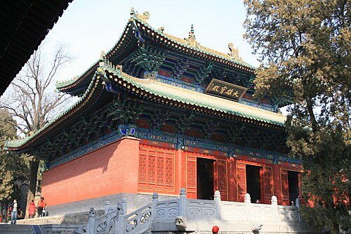
Photo adjustments
Wikimedia thumbnail; fitted to the ranking-card frame.
- Administrative area
- County-level city · 县级市
- Part of
- Zhengzhou
- Chinese name
- 登封市
- Local areas
- County-level city guide
Area & population
- Area in the source
- 1,220.00 km²
- Population · 2019
- 717,400
Source: cited geographic source, as of the dates shown.
Setting and landscape
Mount Song is the main range in the north of the city and splits into two massifs, Taishi (太室山) north of the town and Shaoshi (少室山). Junji Peak (峻极峰) on Taishi, at 1,494 metres, is the main summit. The Ying River (颍河) rises on Shaoshi and flows east through the Baisha Reservoir (白沙水库) towards the Huai; Mount Ji (箕山) and the Xiong (熊山) range lie to the south. Mount Song was among the first Global Geoparks, and Sanhuangzhai (三皇寨), 15 kilometres west of the city, is presented by the city government as the geopark's most representative landscape, with a cliff-hung plank walkway, a stone forest and a suspension bridge.
History
The city government places Yangcheng (阳城), the earliest capital of the Xia, at today's Gaocheng town (告成镇), where in the 11th century BC the Duke of Zhou (周公) measured the sun's shadow and took the spot as the centre of heaven and earth. In 696 Empress Wu Zetian (武则天) performed the sacrifices on Mount Song and renamed Songyang County "Dengfeng", meaning to ascend the mountain and hold the feng rite. The county became a city in 1994.
What to see
The Historic Monuments of Dengfeng in "The Centre of Heaven and Earth" (登封“天地之中”历史建筑群) became a World Heritage site in 2010. The group has eight parts: the Taishi Que gate towers with Zhongyue Temple (中岳庙), the Shaoshi and Qimu gate towers, the Songyue Temple Pagoda (嵩岳寺塔), the Shaolin Temple complex with its Pagoda Forest (塔林) and Chuzu Hermitage (初祖庵), Huishan Temple (会善寺), the Songyang Academy (嵩阳书院) and the Observatory (观星台). The city counts 367 surviving buildings in them, from the Eastern Han to the Republican era.
Chinese Wikipedia describes the Songyue pagoda as China's oldest surviving Buddhist brick pagoda and the Songyang Academy as one of the four great academies of the Song dynasty. The Observatory, 12 kilometres southeast of the city, was built by the Yuan astronomer Guo Shoujing (郭守敬); the site also holds the Duke of Zhou's shadow-measuring platform and a museum of the Yangcheng ruins.
Crafts
Dengfeng kiln ware (登封窑) traces back to the Sui and Tang. Its kilns include Quhe (曲河窑) at Gaocheng, known for incised decoration on a "pearl" ground, Tang–Song white-ware sites around Qianzhuang in Xuanhua (宣化镇), and Jin–Yuan Jun ware kilns at Chengyao in Baiping (白坪乡). Its firing technique entered the national intangible heritage list in 2014.
Highlights
- Shaolin Temple 少林寺: National 5A scenic area and part of the 2010 World Heritage group, with its Pagoda Forest and Chuzu Hermitage.
- Songyue Temple Pagoda 嵩岳寺塔: Described as China's oldest surviving Buddhist brick pagoda.
- Songyang Academy 嵩阳书院: One of the four great academies of the Song dynasty; part of the World Heritage group.
- Gaocheng Observatory 观星台: Built by the Yuan astronomer Guo Shoujing, 12 km southeast of the city.
- Zhongyue Temple 中岳庙: Listed with the Taishi Que gate towers as part of the World Heritage group.
- Sanhuangzhai 三皇寨: Geopark landscape 15 km west of the city, with a cliff-hung plank walkway and stone forest.
Sources for this guide
登封市 - 维基百科,自由的百科全书 · Wikipedia (Chinese) · CC BY-SA 4.0
登封概况 - 登封市人民政府 · Dengfeng Municipal People's Government
物质文化遗产 - 登封市人民政府 · Dengfeng Municipal People's Government
国家级非物质文化遗产——登封窑 - 登封市人民政府 · Dengfeng Municipal People's Government
三皇寨 - 登封市人民政府 · Dengfeng Municipal People's Government
观星台 - 登封市人民政府 · Dengfeng Municipal People's Government
Original English written from the listed sources and checked sentence by sentence against quoted extracts by a separate reviewer. Updated 2026-09-25.
Explore Dengfeng
Core places to explore, with English and Chinese names.
Places to explore around Dengfeng
 Zhongyue Temple in Dengfeng after snowfall, January 2026.
Zhongyue Temple中岳庙
Zhongyue Temple lies below the eastern side of Taishi Mountain at Dengfeng. It is a Taoist temple associated with the sacred Central Mountain and imperial mountain worship.
Read the place guide →Monastero Shaolin (Shaolin Temple) · 少林寺Shaolin Temple少林寺
Shaolin Temple occupies the foot of Wuru Peak in the Songshan range. Beyond its martial-arts reputation, the visit follows a monastic axis of gates and halls, with buildings from different periods and later reconstructions…
Read the place guide →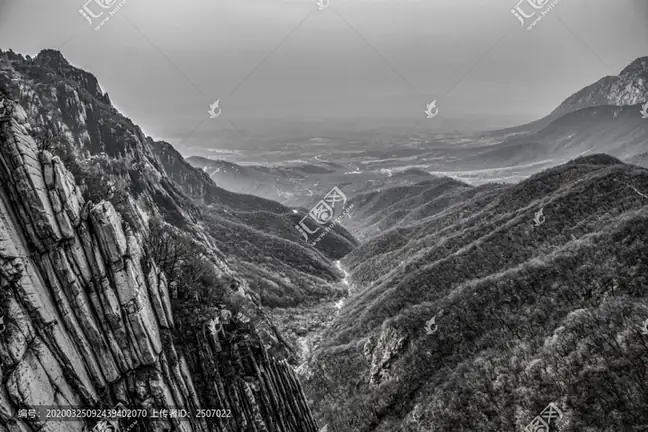 Mount Song Sanhuangzhai Scenic Area · 嵩山三皇寨
Mount Song Sanhuangzhai Scenic Area嵩山三皇寨
Sanhuangzhai (嵩山三皇寨) is a ridge and cliff section of Shaoshi Mountain about 15 kilometres west of the town of Dengfeng, in Zhengzhou, Henan, and one of the ten visitor areas of the Songshan UNESCO Global Geopark.
Read the place guide → The brick pagoda of Songyue Temple on Mount Song, Dengfeng · 登封嵩岳寺塔,嵩山南麓 Source-recorded photograph date: 2015-09-25 10:45:51.
Songyue Temple Pagoda嵩岳寺塔
Twelve-sided Northern Wei brick pagoda of the 520s near Dengfeng, the earliest known multi-eaved pagoda in China and part of a World Heritage Site.
Read the place guide → The main gate of Songyang Academy, Dengfeng · 登封嵩阳书院大门 Source-recorded photograph date: 2025-06-29 19:03:01.
Songyang Academy嵩阳书院
Confucian academy below Mount Song's Junji Peak near Dengfeng, founded as a temple in 484, where the Cheng brothers taught; part of a World Heritage Site.
Read the place guide → Gaocheng Astronomical Observatory, Dengfeng, Henan, photographed in June 2025.
Gaocheng Astronomical Observatory观星台
Gaocheng Observatory makes astronomical measurement visible in brick and stone. Its Yuan-period platform supported a horizontal bar whose shadow fell along a long stone measuring scale extending northward. Water channels helped…
Read the place guide →Plan your visit
Getting there
Dengfeng is about 70 km in a straight line from central Zhengzhou. Search for 登封市 in a map app to find stations and your accommodation.
Where to stay →Build your route
Zhongyue Temple and Shaolin Temple are about 15 km apart in a straight line. The linked place guides have entrance and visit details.
Continue with Zhengzhou →More in Zhengzhou
Sources & geographic information
Administrative names and parent areas: Official geographic directory · Reference date 2026-09-06.
Some facts checked against 登封市 — Wikipedia contributors, CC BY-SA 4.0.
Photo: Zhongyue Temple · Windmemories · CC BY-SA 4.0. Proportionally resized and converted to WebP without cropping, retouching or changing the photographed subject.

Photo: Shaolin Temple · Gary Todd from Xinzheng, China · CC0. Wikimedia thumbnail; fitted to the ranking-card frame.
.jpg)
Photo: Mount Song Sanhuangzhai Scenic Area · Source photographer · License not provided. EXIF orientation normalized; resized without changing aspect ratio; converted to WebP. No subject edits.
Photo: Songyue Temple Pagoda · Siyuwj · CC BY-SA 4.0. Full frame retained; proportionally resized and converted to WebP. No retouching or changes to the photographed subject. Card displays may crop the view.

Photo: Songyang Academy · Windmemories · CC BY-SA 4.0. Full frame retained; proportionally resized and converted to WebP. No retouching or changes to the photographed subject. Card displays may crop the view.

Photo: Gaocheng Astronomical Observatory · Windmemories · CC BY-SA 4.0. Proportionally resized and converted to WebP without cropping, retouching or changing the photographed subject.

Map data © OpenStreetMap contributors. Pins mark approximate centres, not entrances or boundaries.