


Get to know Hanyang District
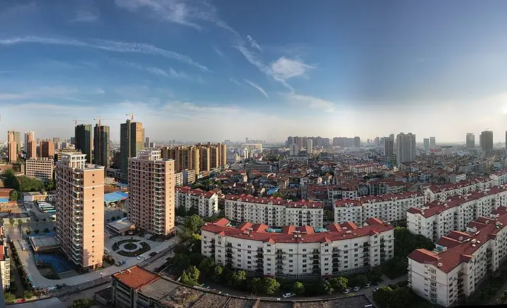
Photo adjustments
Full frame retained; proportionally resized and converted to WebP. No retouching or changes to the photographed subject. Card displays may crop the view.
- Administrative area
- District · 市辖区
- Part of
- Wuhan
- Chinese name
- 汉阳区
- Local areas
- District guide
Area & population
- Area in the source
- 108.34 km²
- Population · 2020
- 837,263
Source: cited geographic source, as of the dates shown.
History
Chinese Wikipedia records a Hanyang County from the Sui dynasty and a walled town built south of Fengqi Hill (凤栖山) in 621; from the Yuan to the Qing the town was the seat of Hanyang prefecture. In 1949 its urban area was joined with Wuchang and Hankou (汉口) to form Wuhan. The name means "north of the Han", but a shift in the lower Han's course in the Ming Chenghua reign left the town on the river's south bank, and the old name stayed.
In the late Qing, the reformer Zhang Zhidong (张之洞) founded the Hanyang Arsenal (汉阳兵工厂), whose rifles were known as "Hanyang-made" (汉阳造); Hanyang was also the site of the Hanyang Iron Works (汉阳铁厂). The Hanyang Zao creative park ("汉阳造"文化创意产业园) now occupies a former factory site on the north foot of Tortoise Hill (龟山), opened in stages from 2011.
What to see
Tortoise Hill, rising to 90 m above sea level, faces Snake Hill (蛇山) across the Yangtze in Wuchang, and its slopes hold the tombs of Lu Su (鲁肃) and Mi Heng (祢衡). On its eastern foot, Qingchuan Pavilion (晴川阁), first built in the early Ming and named from a line of Cui Hao's (崔颢) poem "Yellow Crane Tower", is a national monument; the present buildings were rebuilt between 1983 and 1991 from late-Qing photographs.
West of the hill, Guqin Terrace (古琴台) marks the legend of the musician Boya (伯牙) and Zhong Ziqi (钟子期), the friend who understood his music; the present buildings date from after 1957, and the legend has been on the national intangible heritage list since 2014. Beside it lies Moon Lake (月湖), with the Qintai Grand Theatre (琴台大剧院), the Qintai Concert Hall (琴台音乐厅) and the Wuhan Art Museum's Qintai branch on its north shore.
Guiyuan Temple (归元禅寺), founded in 1658, is made up of more than 20 main buildings, among them a hall of arhats (罗汉堂). At Nan'anzui (南岸嘴), the tip of land between the two rivers, a riverside park looks out on the meeting of the Yangtze and Han.
Highlights
- Qingchuan Pavilion 晴川阁: Early-Ming pavilion on Tortoise Hill's eastern foot, rebuilt 1983–1991; national monument.
- Guqin Terrace 古琴台: Memorial to the Boya and Zhong Ziqi legend, national intangible heritage since 2014.
- Guiyuan Temple 归元禅寺: Buddhist temple founded in 1658 with more than 20 main buildings.
- Nan'anzui 南岸嘴: Park at the confluence of the Yangtze and Han rivers.
- Tortoise Hill 龟山: Hill rising to 90 m above sea level, facing Snake Hill across the Yangtze, with the tombs of Lu Su and Mi Heng.
Sources for this guide
汉阳概况 · Hanyang District People's Government, Wuhan
汉阳区 · Wikipedia (Chinese) · CC BY-SA 4.0
风景名胜 · Hanyang District People's Government, Wuhan
Original English written from the listed sources and checked sentence by sentence against quoted extracts by a separate reviewer. Updated 2026-09-25.
Explore Hanyang District
Core places to explore, with English and Chinese names.
Places to explore around Hanyang District
 Qingchuan Pavilion entrance gate, Wuhan · 武汉晴川阁入口 Photograph date recorded by the source: 11 May 2019, 14:36:29.
Qingchuan Pavilion晴川阁
Qingchuan Pavilion occupies a river-facing position on the Hanyang side of Wuhan. The visit joins three distinct elements: the pavilion itself, Yuji Palace and Tiemen Gate. Together they connect a river panorama with the memory…
Read the place guide → Entrance to Guqin Tai, the Lute Platform memorial in Wuhan, November 2019.
Guqin Tai古琴台
Guqin Tai commemorates the story of the musician Boya and Zhong Ziqi, the listener who understood his playing. Its setting between Turtle Hill and Moon Lake gives the musical tradition a quiet landscape context. The memorial has…
Read the place guide → Guiyuan Temple, Wuhan, Hubei.
Guiyuan Temple归元寺
Guiyuan Temple is an active Buddhist precinct in Hanyang whose best-known artistic feature is the hall of five hundred arhats. Their varied poses, expressions and gestures reward a slower look than a quick count. The principal…
Read the place guide →Plan your visit
Getting there
Hanyang District is about 10 km in a straight line from central Wuhan. Search for 汉阳区 in a map app to find stations and your accommodation.
Where to stay →Build your route
Qingchuan Pavilion and Guqin Tai are about 2 km apart in a straight line. The linked place guides have entrance and visit details.
Continue with Wuhan →More in Wuhan
Sources & geographic information
Administrative names and parent areas: Official geographic directory · Reference date 2026-09-06.
Some facts checked against 汉阳区 — Wikipedia contributors, CC BY-SA 4.0.
Photo: Qingchuan Pavilion · Sherbet · Sherbet — Qingchuan Pavilion, Hubei, China.jpg — CC BY 2.5 · CC BY 2.5. The exact downloaded source bytes are separately retained and hashed. Prepared JPEG is proportionally reduced to a maximum 720-pixel long edge; full frame retained, no subject alteration. Final website rendition: full frame retained, proportionally resized to at most 720 pixels and converted to WebP. No additional retouching or subject alteration. Card displays may crop the view.

Photo: Guqin Tai · kiraclyne · CC BY-SA 4.0. Proportionally resized and converted to WebP without cropping, retouching or changing the photographed subject.

Photo: Guiyuan Temple · Gisling · CC BY 3.0. Proportionally resized and converted to WebP without cropping, retouching or changing the photographed subject.

Map data © OpenStreetMap contributors. Pins mark approximate centres, not entrances or boundaries.