


Get to know Jiang'an District
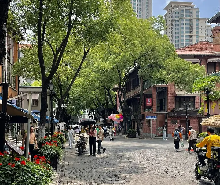
Photo adjustments
Full frame retained; proportionally resized and converted to WebP. No retouching or changes to the photographed subject. Card displays may crop the view.
- Administrative area
- District · 市辖区
- Part of
- Wuhan
- Chinese name
- 江岸区
- Local areas
- District guide
Area & population
- Area in the source
- 64.24 km²
- Population · 2020 census
- 965,260
- Administrative seat
- Tazihu Subdistrict
Source: cited geographic source, as of the dates shown.
History
After Hankou opened as a treaty port in 1861, Britain, Russia, France, Germany and Japan set up concessions here and some 20 countries opened consulates. Merchants and missionaries from 17 countries built trading houses, banks, factories and wharves, and the district government notes that electric light and the telegraph appeared here first. Catholic, Protestant and Orthodox churches still stand, alongside Hankou-style lane houses (汉派里分).
The district also holds several revolutionary sites: it was the starting point of the February 7th Strike (二七大罢工), and on 7 August 1927 the Communist Party held its August 7th Meeting (八七会议) here. The former sites of the party's central organs, the Eighth Route Army office and the New Fourth Army headquarters are also here.
What to see
The Yangtze frontage runs for 16.2 km, the longest in Hankou; the Hankou riverside park (汉口江滩) and a row of restored historic riverside buildings together make up the district's riverside leisure strip.
Li Huangpi Road (黎黄陂路), a 604 m street running from the riverside avenue to Zhongshan Avenue, was built in 1900 inside the Russian concession and renamed in 1946 after the former president Li Yuanhong (黎元洪), whose family came from Huangpi. About 17 European-style buildings survive along it, including the former Russian municipal council and the Russo-Chinese Bank. The district opened a street museum on the road in 1997, and in 2023 it was named a national tourism and leisure street.
Guide Temple (古德寺), founded in 1877 by the monk Longxi (隆希), became a public monastery in 1914, when Li Yuanhong gave it its present name. Its main hall, begun in 1921 and finished 13 years later, carries nine stupas on its roof, standing for five buddhas and four bodhisattvas; visiting in 1954, the Indian prime minister Nehru was surprised to find a temple in an Indian style in Wuhan. It has been a national monument since 2013.
Highlights
- Li Huangpi Road 黎黄陂路: Former Russian-concession street with about 17 European-style buildings; national tourism and leisure street since 2023.
- Guide Temple 古德寺: Buddhist temple founded in 1877 with nine stupas on its main hall; national monument since 2013.
- Hankou riverside park 汉口江滩: Riverside park on the district's 16.2 km Yangtze frontage, the longest in Hankou.
- August 7th Meeting site 八七会议: Site of the Communist Party meeting held on 7 August 1927.
Sources for this guide
历史沿革 · Jiang'an District People's Government, Wuhan
基本概况 · Jiang'an District People's Government, Wuhan
古德寺 · Wikipedia (Chinese) · CC BY-SA 4.0
黎黄陂路 · Wikipedia (Chinese) · CC BY-SA 4.0
Original English written from the listed sources and checked sentence by sentence against quoted extracts by a separate reviewer. Updated 2026-09-25.
Explore Jiang'an District
Core places to explore, with English and Chinese names.
Places to explore around Jiang'an District
 A broad view along the Yangtze at Hankou: a paved riverside promenade with stone paving and dark lamp columns at the right, a sandy beach strip where people stand at the water's edge, kite-flyers and strollers spread across the walk, a pier with pavilions mid-river, and the Hankou tower skyline across the water under an overcast sky.
Hankou Riverside Park汉口江滩
Hankou Riverside (汉口江滩) is the park along the left bank of the Yangtze in Wuhan, running about seven kilometres beside Yanjiang Avenue, built as flood defence on a sediment flat laid down by the river itself.
Read the place guide →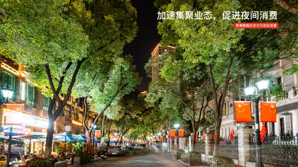 Lihuangpi Road Historic District · 黎黄陂路历史街区
Lihuangpi Road Historic District黎黄陂路历史街区
Lihuangpi Road (黎黄陂路) is a 604-metre street in the former Hankou Russian Concession of Jiang'an District, Wuhan, laid out in 1900 and now managed as a historic and cultural street lined with concession-era buildings.
Read the place guide → The Western-influenced facade of Gu De Si (Gude Temple) in Jiang'an District, Wuhan · 武汉市江岸区古德寺融合西式风格的殿宇立面 Source-recorded photograph date: 2023-04-08.
Gude Temple古德寺
Hankou Buddhist temple founded in 1877 that tended 1911 revolutionaries, known for its 1920s main hall modelled on Myanmar's Ananda Temple.
Read the place guide →Plan your visit
Getting there
Jiang'an District is about 6 km in a straight line from central Wuhan. Search for 江岸区 in a map app to find stations and your accommodation.
Where to stay →Build your route
Hankou Riverside Park and Lihuangpi Road Historic District are both listed here. The linked place guides have entrance and visit details.
Continue with Wuhan →More in Wuhan
Sources & geographic information
Administrative names and parent areas: Official geographic directory · Reference date 2026-09-06.
Some facts checked against 古德寺 — Wikipedia contributors, CC BY-SA 4.0.
Some facts checked against 黎黄陂路 — Wikipedia contributors, CC BY-SA 4.0.
Photo: Hankou Riverside Park · Chen Huang · CC BY 3.0. Full frame retained; proportionally resized and converted to WebP. No retouching or changes to the photographed subject. Card displays may crop the view.

Photo: Lihuangpi Road Historic District · Source photographer · License not provided. EXIF orientation normalized; resized without changing aspect ratio; converted to WebP. No subject edits.
Photo: Gude Temple · ScareCriterion12 · CC0. Full frame retained; proportionally resized and converted to WebP. No retouching or changes to the photographed subject. Card displays may crop the view.
.jpg)
Map data © OpenStreetMap contributors. Pins mark approximate centres, not entrances or boundaries.