


Get to know Wuchang District
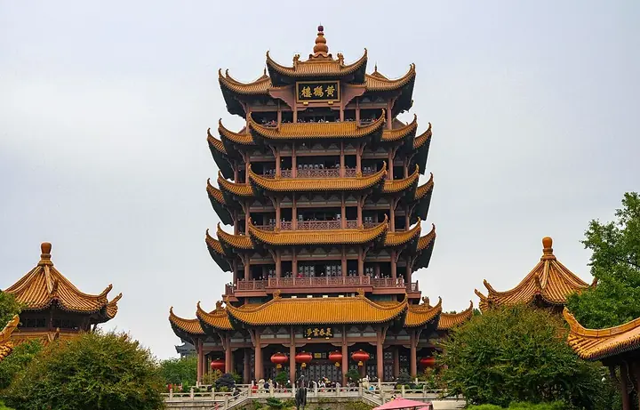
Photo adjustments
Full frame retained; proportionally resized and converted to WebP. No retouching or changes to the photographed subject. Card displays may crop the view.
- Administrative area
- District · 市辖区
- Part of
- Wuhan
- Chinese name
- 武昌区
- Local areas
- District guide
Area & population
- Area in the source
- 87.42 km²
- Population · 2020
- 1,102,188
Source: cited geographic source, as of the dates shown.
Setting and landscape
Most of the district is plain, broken by isolated hills including Snake Hill (蛇山), Fenghuang Hill (凤凰山), Hong Hill (洪山) and Luojia Hill (珞珈山), with Sha Lake (沙湖) and East Lake (东湖) among its lakes. The old walled town was known for "nine lakes and thirteen hills"; of the nine, only Ziyang Lake (紫阳湖) and Dusi Lake (都司湖) still hold water.
History
The district government dates the town to 223, when Sun Quan (孙权) of Wu built the fort of Xiakou (夏口城) on the north side of Snake Hill to control the Yangtze, with a watchtower on Huanghu Rock (黄鹄矶) that was the early form of the Yellow Crane Tower. The name Wuchang has been used for this part of the city since 1301. In 1371 the walls were enlarged, with nine gates, and from 1381 the Ming Prince of Chu's palace south of Snake Hill took up nearly half the town. The walls were pulled down between 1927 and 1929, leaving a few remains such as Qiyi Gate (起义门).
Zhang Zhidong (张之洞), Viceroy of Huguang from 1889, founded cloth, yarn, silk and hemp mills and new schools here, some of them forerunners of Wuhan University. On 10 October 1911 the Wuchang Uprising broke out. In 1927 Mao Zedong wrote his report on the Hunan peasant movement at Dufudi (都府堤), and on 27 April that year the Communist Party's Fifth Congress opened at the Hubei Provincial First Primary School (湖北省立第一小学). In 1938 the wartime propaganda office known as the Third Department was set up in Tanhualin (昙华林).
What to see
Besides the Yellow Crane Tower, Chinese Wikipedia lists the Hubei Provincial Museum (湖北省博物馆), the Hubei Military Government headquarters known as the Red Building (红楼), Changchun Temple (长春观), Baotong Temple (宝通禅寺), Wuhan University and the Wuchang riverside park (武昌江滩) among the district's sights. The Wuhan Yangtze River Bridge, opened on 15 October 1957, was the first road-and-rail bridge built across the Yangtze after 1949.
Highlights
- Yellow Crane Tower 黄鹤楼: Grew from a Wu watchtower of 223 on Huanghu Rock into a site celebrated by Tang and Song poets.
- Qiyi Gate 起义门: One of the few remains of the Wuchang city wall, demolished 1927–1929.
- Red Building 红楼: Former headquarters of the Hubei military government of the Republic of China.
- Tanhualin 昙华林: Where the wartime Third Department was set up in 1938.
- Wuhan Yangtze River Bridge 武汉长江大桥: Road-and-rail bridge opened on 15 October 1957.
Explore Wuchang District
Core places to explore, with English and Chinese names.
Places to explore around Wuchang District
 A view across East Lake: a carved white stone balustrade with lotus-bud posts in the foreground, wide blue water behind it, a tree-lined far shore, and the high-rise skyline of Wuchang rising along the horizon under a clear blue sky.
East Lake东湖
East Lake (东湖) is a large freshwater lake inside the city of Wuhan, Hubei, at the centre of a scenic area that has been protected as one of China's first national key scenic and historic areas.
Read the place guide →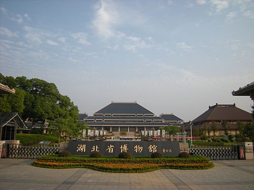 Hubei Provincial Museum · 湖北省博物馆
Hubei Provincial Museum湖北省博物馆
Hubei Provincial Museum is a strong introduction to the ancient states of Chu and Zeng. The bronze bells from the tomb of Marquis Yi and the Sword of Goujian make two very different kinds of metalwork tangible: musical precision…
Read the place guide → 1911 Revolution Museum (辛亥革命博物院), Wuchang District. Photograph: "WuchangUprising".
1911 Revolution Museum辛亥革命博物院
The 1911 Revolution Museum (辛亥革命博物院) in Wuchang District, Wuhan, is the institution built around the Red Building at Yuemachang, the 1910 assembly hall where the Hubei Military Government of the Republic of China was formed the day after the Wuchang Uprising.
Read the place guide → Yellow Crane Tower · 黄鹤楼
Yellow Crane Tower黄鹤楼
Yellow Crane Tower rises above Snake Hill with layered roofs and wide views towards the Yangtze. Its literary fame is much older than the building: the present tower was completed in 1985 after earlier versions repeatedly burned…
Read the place guide → Traditional brick buildings with red awnings along a street in the Tanhualin historic quarter, Wuchang District, Wuhan · 武汉市武昌区昙华林历史文化街区的传统建筑街景 Source-recorded photograph date: 2021-10-10 16:48:50.
Tanhualin Historic District昙华林
Car-free street in old Wuchang, Wuhan, that took shape after 1371, with churches, mission buildings and houses from 1864 to 1937.
Read the place guide →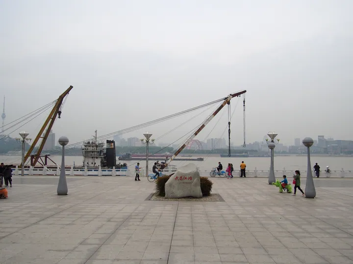 Waterfront plaza with a marker stone reading Wuchang Jiangtan and a view across the Yangtze River, Wuchang District, Wuhan · 武汉市武昌区武昌江滩,江边广场及长江对岸景观 Source-recorded photograph date: Taken on 9 April 2016.
Wuchang Riverside Park武昌江滩
Wuchang Riverside (武昌江滩) is the park along the right bank of the Yangtze in Wuchang District, Wuhan, part of the city's Hundred-li Yangtze Ecological Corridor and built on top of the river's flood defences.
Read the place guide → AI illustration · AI 示意图(仅供参考,非该地点实拍)
Wuhan University Campus武汉大学校园
The Wuhan University campus (武汉大学校园) occupies Luojia Hill and the hills around it beside East Lake in Wuchang District, Wuhan, and contains a group of buildings from China's modern era protected as a national key cultural heritage site.
Read the place guide →Plan your visit
Getting there
Wuchang District is about 6 km in a straight line from central Wuhan. Search for 武昌区 in a map app to find stations and your accommodation.
Where to stay →Build your route
East Lake and Hubei Provincial Museum are both listed here. The linked place guides have entrance and visit details.
Continue with Wuhan →More in Wuhan
Sources & geographic information
Administrative names and parent areas: Official geographic directory · Reference date 2026-09-06.
Some facts checked against 武昌区 — Wikipedia contributors, CC BY-SA 4.0.
Photo: East Lake · fllee · CC BY-SA 3.0. Full frame retained; proportionally resized and converted to WebP. No retouching or changes to the photographed subject. Card displays may crop the view.

Photo: Hubei Provincial Museum · No machine-readable author provided. 风之清扬 assumed (based on copyright claims). · CC BY-SA 3.0. Wikimedia thumbnail; fitted to the ranking-card frame.

Photo: 1911 Revolution Museum · Mongol · CC BY-SA 3.0. Full frame retained; EXIF orientation normalized, proportionally resized to at most 800 pixels and converted to WebP. No generated pixels or subject changes. Cards may crop the display.

Photo: Yellow Crane Tower · MonsieurRoi · CC BY-SA 3.0. Wikimedia thumbnail; fitted to the ranking-card frame.

Photo: Tanhualin Historic District · Augustokremo · CC BY-SA 4.0. Full frame retained; proportionally resized and converted to WebP. No retouching or changes to the photographed subject. Card displays may crop the view.

Photo: Wuchang Riverside Park · Chen Huang · CC BY 3.0. Full frame retained; proportionally resized and converted to WebP. No retouching or changes to the photographed subject. Card displays may crop the view.

Map data © OpenStreetMap contributors. Pins mark approximate centres, not entrances or boundaries.