


Get to know Jiangyou
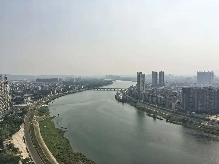
Photo adjustments
Full-frame source proportionally resized and converted to WebP for display. No subject alteration. Source-supplied marks and edits remain; cards may crop the view.
- Administrative area
- County-level city · 县级市
- Part of
- Mianyang
- Chinese name
- 江油市
- Local areas
- County-level city guide
Area & population
- Area in the source
- 2,719.00 km²
- Population · 2020 census
- 731,343
- Administrative seat
- Zhongba
Source: cited geographic source, as of the dates shown.
Setting and landscape
The land rises from southeast to northwest. Flat ground along the Fu River gives way to broad hilly valleys in the centre and south, and to the Longmen Mountains (龙门山) in the northwest, where Jiaoziding (轿子顶) reaches 2,356 metres. The Fu River runs 62.3 km through the city, and the Tongkou River (通口河), coming down from Beichuan, joins it at Qinglian (青莲镇).
History
A Jiangyou County was first set up in 505 under the Northern Wei, at present-day Nanba in Pingwu; the name is explained as the Fu River running as clear as oil. Jiangyou and Zhangming (彰明) counties were merged in 1958, the name Jiangyou returned in 1959, and the county became a city in 1988. The city government counts 32 surviving sites linked to Li Bai, among them Longxi Courtyard (陇西院), the Taibai Shrine (太白祠) and Mozhen Stream (磨针溪), and it counts the tale of grinding an iron pestle into a needle among the legends he left here; Deng Xiaoping wrote the inscription "李白故里" ("Li Bai's home town"). Jiangyou also claims to be the birthplace of Nezha (哪吒) culture, at Mount Cuiping (翠屏山), Mount Qianyuan (乾元山) and Jinguang Cave (金光洞), and a long gunpowder tradition: the Laojunshan saltpetre cave site (老君山硝洞遗址) is a nationally protected monument that the city describes as the largest ancient saltpetre cave site found in China.
What to see
Jiangyou has five 4A scenic areas: the Li Bai Memorial Hall (李白纪念馆), Li Bai's Former Residence (李白故居), Mount Douchuan (窦圌山), Foyedong (佛爷洞) and Zhonghua Dongtian (中华洞天). Mount Douchuan, in Wudu (武都镇), is named after Dou Chuan, a Tang official said to have lived there as a recluse. A line Li Bai wrote about it is carved on a tablet in the calligraphy of Yu Youren (于右任). Foyedong, in Dakang (大康镇), is a karst cave and national geopark with an underground river, the Tongtian (通天河), running through it, explored by bamboo raft; scenes of CCTV's Journey to the West were filmed there. The Yunyan Temple (云岩寺) and the Qinglinkou old buildings (青林口古建筑群) are national heritage sites.
Food and local products
Jiangyou pork intestines (江油肥肠) are made by a technique on Sichuan's provincial intangible-heritage list, as is the brewing of Zhongba mushroom soy sauce (中坝口蘑酱油). Jiangyou lily (江油百合) is a national geographical-indication product.
Getting oriented
Jiangyou lies 35 km from Mianyang and 160 km from Chengdu. The Baoji–Chengdu railway and the Xi'an–Chengdu high-speed line run through the city, with Jiangyou, Jiangyou North and Qinglian stations.
Highlights
- Li Bai's Former Residence 李白故居: One of the five 4A scenic areas; the city counts 32 surviving sites linked to the poet.
- Mount Douchuan 窦圌山: 4A mountain in Wudu named after the Tang recluse Dou Chuan, with Li Bai's verse carved in Yu Youren's hand.
- Foyedong 佛爷洞: 4A karst cave and national geopark with an underground river toured by bamboo raft.
- Laojunshan saltpetre cave site 老君山硝洞遗址: National heritage site linked to Jiangyou's gunpowder history.
- Jiangyou pork intestines 江油肥肠: Preparation technique on the provincial intangible-heritage list.
Sources for this guide
文旅概况_江油市人民政府 · Jiangyou Municipal People's Government
窦圌山景区_江油市人民政府 · Jiangyou Municipal People's Government
佛爷洞景区_江油市人民政府 · Jiangyou Municipal People's Government
江油市 · Wikipedia (Chinese) · CC BY-SA 4.0
Original English written from the listed sources and checked sentence by sentence against quoted extracts by a separate reviewer. Updated 2026-09-25.
Explore Jiangyou
Core places to explore, with English and Chinese names.
Places to explore around Jiangyou
 Main gateway inscribed 'Li Bai's Hometown' at the entrance to the Li Bai memorial complex, Jiangyou, Mianyang · 四川省绵阳市江油市李白故里景区大门 Source-recorded photograph date: Taken on 5 October 2015.
Li Bai's Hometown李白故里
Li Bai's Hometown is the scenic area at Li Bai's former residence in Qinglian town, Jiangyou, Mianyang, Sichuan. The Sichuan Provincial Local Chronicles Office records that the Tang poet was born in the same township. Longxi Yuan, the site of his former residence, was listed as a Sichuan provincial cultural relic protection unit in 1961.
Read the place guide → Douchuan Mountain (窦圌山), Jiangyou. Photograph: "江油云岩寺飞天藏".
Douchuan Mountain窦圌山
Douchuan Mountain is a mountain whose main peak stands in bare conglomerate Danxia rock, north-east of Wudu town, the old county seat of Jiangyou, Mianyang, Sichuan, and the site of Yunyan Temple. It is a national AAAA-grade tourist area, a national geopark and a national key cultural relic protection unit.
Read the place guide →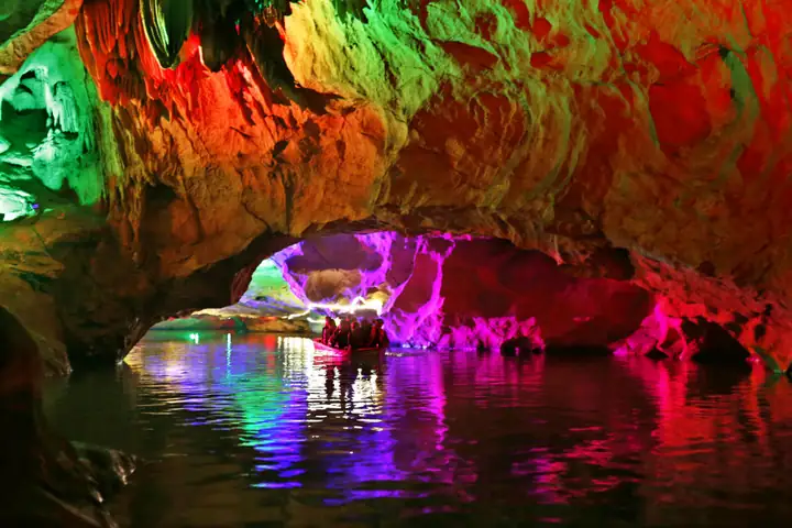 Foye Cave · 佛爷洞
Foye Cave佛爷洞
Karst cave with an underground river in Dakang Town, 14 km from Jiangyou, named for a stone Buddha found inside; a national AAAA scenic area.
Read the place guide →Plan your visit
Getting there
Jiangyou is about 35 km in a straight line from central Mianyang. Search for 江油市 in a map app to find stations and your accommodation.
Where to stay →Build your route
Li Bai's Hometown and Douchuan Mountain are both listed here. The linked place guides have entrance and visit details.
Continue with Mianyang →More in Mianyang
Sources & geographic information
Administrative names and parent areas: Official geographic directory · Reference date 2026-09-06.
Some facts checked against 江油市 — Wikipedia contributors, CC BY-SA 4.0.
Photo: Li Bai's Hometown · ping lin · CC BY-SA 3.0. Full frame retained; proportionally resized and converted to WebP. No retouching or changes to the photographed subject. Card displays may crop the view.
.jpg)
Photo: Douchuan Mountain · Nekitarc · CC BY-SA 4.0. Full frame retained; EXIF orientation normalized, proportionally resized to at most 800 pixels and converted to WebP. No generated pixels or subject changes. Cards may crop the display.

Photo: Foye Cave · Source photographer · License not provided. EXIF orientation normalized; resized without changing aspect ratio; converted to WebP. No subject edits.
Map data © OpenStreetMap contributors. Pins mark approximate centres, not entrances or boundaries.