


Get to know Huizhou District
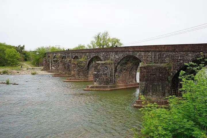
Photo adjustments
Full frame retained; resized proportionally to a maximum dimension of 960 pixels and converted to WebP quality 88. No crop, retouch, generated elements, or subject alteration. Final website rendition: full frame retained, proportionally resized to at most 720 pixels and converted to WebP. No additional retouching or subject alteration. Card displays may crop the view.
- Administrative area
- District · 市辖区
- Part of
- Huangshan
- Chinese name
- 徽州区
- Local areas
- District guide
Area & population
- Area in the source
- 419.42 km²
- Population · 2020
- 96,162
- Administrative seat
- Yansi
Source: cited geographic source, as of the dates shown.
History
The district was created in November 1987, when Huangshan City was set up. Anhui Daily calls Yansi the place where Red Army guerrillas from eight southern provinces gathered and were reorganised into the New Fourth Army (新四军). In February 1938 the army's southern units were ordered to assemble around Yansi for training, and on 4 April 1938 the army headquarters moved there from Nanchang (南昌). Two small houses at the Hong Bridge (洪桥) on Yansi's back street served that spring as its confidential office and telegraph room, and the headquarters site now has a memorial hall rated as a 4A scenic area.
What to see
National protected sites in the district include the Qiankou residences (潜口民宅), where more than ten typical Ming buildings from Zhengcun, Xucun, Qiankou, Xixinan and other places that could not be kept where they stood were taken down from 1984 and rebuilt in their original form, work that was largely finished by 1990.
Chengkan (呈坎村) lies in a basin ringed by eight peaks, with the Zhongchuan River (潨川河) along its east side; the Luo clan (罗氏) founded it at the end of the Tang. Its Luo Dongshu Ancestral Hall (罗东舒祠) was listed in 1996, twenty other old buildings as the Chengkan building group in 2001, and 28 more in 2013. Another national protected site is the Laowuge house and Lüraoting pavilion (老屋阁及绿绕亭) at Xixinan (西溪南).
Tangmo village (唐模村), a Chinese historic and cultural village since 2007, has the Tangan stream (檀干溪) running through it and a nationally protected group of the Tangan Garden (檀干园), the Tongbao Hanlin archway (同胞翰林坊), the Gaoyang covered bridge (高阳桥) and the Shadi Pavilion (沙堤亭).
Food and local products
Yansi Old Street (岩寺老街) sells Lingshan fermented rice (灵山酒酿), fermented-rice cakes (酒酿饼), Qiankou wontons (潜口馄饨), Chengkan hairy tofu (呈坎毛豆腐), puffed-rice candy (冻米糖) and sesame candy (芝麻糖), all named by China News Service as Huizhou specialities.
Highlights
- Chengkan 呈坎: Luo clan village in a basin of eight peaks; Luo Dongshu Ancestral Hall and a protected group of old buildings.
- Qiankou residences 潜口民宅: Ming buildings moved from around the region and rebuilt from 1984; national protected site.
- Tangmo 唐模: Historic village on the Tangan stream with a garden, archway, covered bridge and pavilion.
- New Fourth Army headquarters site 岩寺新四军军部旧址: Headquarters moved to Yansi on 4 April 1938; memorial hall is a 4A scenic area.
Sources for this guide
徽州区 - 维基百科,自由的百科全书 · Chinese Wikipedia · CC BY-SA 4.0
呈坎村 - 维基百科,自由的百科全书 · Chinese Wikipedia · CC BY-SA 4.0
潜口民宅 - 维基百科,自由的百科全书 · Chinese Wikipedia · CC BY-SA 4.0
唐模村 - 维基百科,自由的百科全书 · Chinese Wikipedia · CC BY-SA 4.0
老街不老,“想你的风”吹进岩寺_中国新闻网安徽 · China News Service, Anhui (ah.chinanews.com.cn)
【胜利之路】铭记峥嵘岁月 凝聚奋进力量---安徽新闻网 · Anhui Daily (ahnews.com.cn)
Original English written from the listed sources and checked sentence by sentence against quoted extracts by a separate reviewer. Updated 2026-09-25.
Explore Huizhou District
Core places to explore, with English and Chinese names.
Places to explore around Huizhou District
 Tangmo Ancient Village · 唐模古村
Tangmo Ancient Village唐模古村
Tangmo is a Huizhou village in Qiankou Town whose water street and landscaped village entrance distinguish it from nearby historic settlements. Streams, bridges and traditional buildings form the main walking experience.
Read the place guide →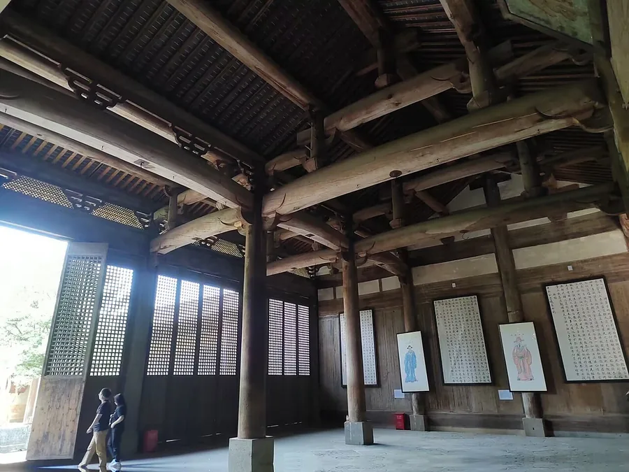 The timber interior of Luo Dongshu Ancestral Hall in Chengkan, Huangshan, Anhui; 16 May 2023.
Chengkan呈坎
Chengkan’s village lanes lead between houses and communal buildings of the Luo clan. The Luo Dongshu ancestral hall is the main architectural focus: its courtyards lead to Baolun Pavilion, where painted timber framing gives the…
Read the place guide → The paifang archway marking the entrance to Tangmo Village, Huizhou District, Huangshan · 黄山市徽州区唐模村"唐模"牌坊入口 Source-recorded photograph date: Taken on 4 April 2015.
Tangmo Village唐模
Tangmo in Huangshan's Huizhou District combines a village water landscape with pavilions, memorial archways and older Huizhou residences.
Read the place guide → The entrance to Qiankou Minzhai's Ming Garden, November 2016.
Qiankou潜口民宅
Qiankou’s historic residences form a collection of Huizhou buildings in Qiankou village. From the 1980s, threatened Ming-period structures from surrounding settlements were dismantled and reconstructed here.
Read the place guide →Plan your visit
Getting there
Huizhou District is about 10 km in a straight line from central Huangshan. Search for 徽州区 in a map app to find stations and your accommodation.
Where to stay →Build your route
Tangmo Ancient Village and Chengkan are both listed here. The linked place guides have entrance and visit details.
Continue with Huangshan →More in Huangshan
Sources & geographic information
Administrative names and parent areas: Official geographic directory · Reference date 2026-09-06.
Some facts checked against 徽州区 — Wikipedia contributors, CC BY-SA 4.0.
Some facts checked against 呈坎村 — Wikipedia contributors, CC BY-SA 4.0.
Some facts checked against 潜口民宅 — Wikipedia contributors, CC BY-SA 4.0.
Some facts checked against 唐模村 — Wikipedia contributors, CC BY-SA 4.0.
Photo: Tangmo Ancient Village · Source photographer · License not provided. EXIF orientation normalized; resized without changing aspect ratio; converted to WebP. No subject edits.
Photo: Chengkan · TIY · CC BY-SA 4.0. Proportionally resized and converted to WebP without cropping, retouching or changing the photographed subject.

Photo: Tangmo Village · 江上清风1961 · CC BY 3.0. Full frame retained; proportionally resized and converted to WebP. No retouching or changes to the photographed subject. Card displays may crop the view.

Photo: Qiankou · Zhangzhugang · CC BY-SA 4.0. Proportionally resized and converted to WebP without cropping, retouching or changing the photographed subject.

Map data © OpenStreetMap contributors. Pins mark approximate centres, not entrances or boundaries.