


Get to know Xihu District

Photo adjustments
Full frame retained; proportionally resized and converted to WebP. No retouching or changes to the photographed subject. Card displays may crop the view.
- Administrative area
- District · 市辖区
- Part of
- Hangzhou
- Chinese name
- 西湖区
- Local areas
- District guide
Area & population
- Area in the source
- 312.43 km²
Source: cited geographic source, as of the dates shown.
Setting and landscape
The west and centre of Xihu District are hill country, an outlying spur of the Tianmu Mountains (天目山) that mostly stays below 300 metres. The north and south are plains crossed by many waterways. The Qiantang River (钱塘江) follows a winding course from south to north, and the Yuhangtang River (余杭塘河) cuts across the north of the district from east to west. The southern part is also known as the Shangsi (上泗) area. It covers the townships of Zhuantang (转塘), Longwu (龙坞) and Shuangpu (双浦) and the Zhijiang National Tourist Resort (之江国家旅游度假区).
What to see
The district counts more than 40 scenic spots. Nine of the Ten Scenes of West Lake (西湖十景) lie within it, including Spring Dawn at Su Causeway (苏堤春晓), Lingering Snow on Broken Bridge (断桥残雪), Three Pools Mirroring the Moon (三潭印月) and Viewing Fish at Flower Harbour (花港观鱼). West Lake and Xixi Wetland are both national 5A scenic areas. Xihu Subdistrict (西湖街道) has been run on the district's behalf by the West Lake Scenic Area administration (西湖风景名胜区管委会) since the end of 2006.
Xixi National Wetland Park (西溪国家湿地公园) lies in the western part of the city, 5 kilometres from West Lake. It is a secondary wetland of about 11.5 square kilometres, named after the Xixi River (西溪河), and took the national wetland park title in 2005. The 2,300-metre Fu Causeway (福堤) runs north to south through the park and links six bridges named with the character fu (福, "good fortune"). The 3,600-metre Shou Causeway (寿堤) is the longest in the wetland.
Zhejiang University (浙江大学) has its Zijingang, Yuquan and Xixi campuses in the district. The Xiangshan campus of the China Academy of Art (中国美术学院), the Zhejiang Conservatory of Music (浙江音乐学院) and the new Zhejiang Library (浙江图书馆) building are in the south. The Wensan Road (文三路) quarter is Hangzhou's long-standing market for electronics and digital goods.
Food and local products
West Lake Longjing tea (西湖龙井茶) grows here: Xihu Subdistrict alone has 5,800 mu of tea gardens. According to China's national intangible-heritage list, the tea comes mainly from Xihu District and is named after Longjing village (龙井村). It dates back to the Tang dynasty, won its reputation under the Song, Yuan and Ming, and was at its peak under the Qing. Growers pan-fire the leaves using ten hand techniques, among them shaking, pressing and grinding. West Lake Longjing tea-making was added to the national list in 2008.
Highlights
- West Lake 西湖: Gives the district its name; nine of the Ten Scenes of West Lake are in the district, and the lake is a national 5A scenic area.
- Xixi National Wetland Park 西溪国家湿地公园: About 11.5 km² of secondary wetland 5 km from West Lake; national wetland park since 2005.
- West Lake Longjing tea 西湖龙井茶: Grown mainly in Xihu District and named after Longjing village; its tea-making was put on the national intangible-heritage list in 2008.
- Zhejiang University 浙江大学: Zijingang, Yuquan and Xixi campuses are in the district.
Sources for this guide
西湖区 - 维基百科,自由的百科全书 · Wikipedia (Chinese) · CC BY-SA 4.0
西溪湿地 - 维基百科,自由的百科全书 · Wikipedia (Chinese) · CC BY-SA 4.0
绿茶制作技艺(西湖龙井) - 中国非物质文化遗产网 · China Intangible Cultural Heritage Network (ihchina.cn)
Original English written from the listed sources and checked sentence by sentence against quoted extracts by a separate reviewer. Updated 2026-09-25.
Explore Xihu District
Core places to explore, with English and Chinese names.
West Lake 西湖
Lingyin Temple 灵隐寺
Xixi National Wetland Park 西溪国家湿地公园
Songcheng 杭州宋城
Feilai Feng 飞来峰
Longjing, Hangzhou 龙井村
Longjing Tea Fields 龙井茶园
Liuhe Pagoda 六和塔
China National Tea Museum 中国茶叶博物馆
Yue Fei Temple 岳王庙
Baochu Pagoda 保俶塔
Xiling Seal Art Society 西泠印社
Zhejiang Provincial Museum 浙江省博物馆
Hangzhou Botanical Garden 杭州植物园
Spring Dawn at Su Causeway 苏堤春晓
Wind and Lotus at the Crooked Courtyard (in Summer) 曲院风荷
Autumn Moon over the Calm Lake 平湖秋月
Lingering Snow on Broken Bridge 断桥残雪
Viewing Fish at Flower Pond 花港观鱼
Three Ponds Mirroring the Moon 三潭映月小瀛洲
Evening Bell Ringing on Nanping Hill 净慈寺南屏晚钟
Mid-Lake Pavilion 湖心亭
Bai Causeway 白堤
Solitary Hill and Zhongshan Park 孤山及中山公园
Yanggong Causeway 杨公堤
Baopu Taoist Temple 抱朴道院
Dreaming of the Tiger Spring 虎跑梦泉
Nine Creeks and Eighteen Gullies 九溪十八涧
Lingyin Temple and Feilai Peak 灵隐寺与飞来峰
Longjing Village and Meijiawu Tea Hills 龙井村与梅家坞茶山
Places to explore around Xihu District
 West Lake (Xi Hu) · 西湖
West Lake西湖
West Lake is a landscape of open water, planted causeways and low hills beside Hangzhou’s older centre. Baochu and Leifeng pagodas mark opposite sides, while Gushan brings gardens and cultural sites into the lake itself. The…
Read the place guide → Lingyin Temple · 灵隐寺
Lingyin Temple灵隐寺
Lingyin climbs the wooded hillside behind Feilai Feng through a succession of Buddhist halls. The Hall of Heavenly Kings introduces the temple’s large sculptural figures; beyond it, the Mahavira Hall shelters a towering gilded…
Read the place guide → Xixi Wetland Park · 西溪国家湿地公园
Xixi National Wetland Park西溪国家湿地公园
Xixi spreads through a network of creeks, ponds and marshes on Hangzhou’s western side. Water channels and planted banks preserve the shape of an agricultural wetland within the expanding city. Willows, persimmons and reeds…
Read the place guide →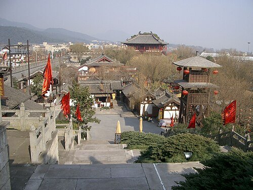 Hangzhou Songcheng · 杭州宋城
Songcheng杭州宋城
Songcheng is a modern performance park that uses Song-style streets and theatrical scenery to stage stories from Hangzhou’s past and legends. The main Songcheng show draws on Liangzhu, the Song court, Yue Fei and the White Snake…
Read the place guide → Rock-carved Buddhist figures at Feilai Feng.
Feilai Feng飞来峰
Feilai Feng’s limestone crags stand across the stream from Lingyin Temple. Buddhist images occupy exposed rock faces and small grottoes, making this an outdoor sculpture visit rather than a summit climb. The broad relief of…
Read the place guide →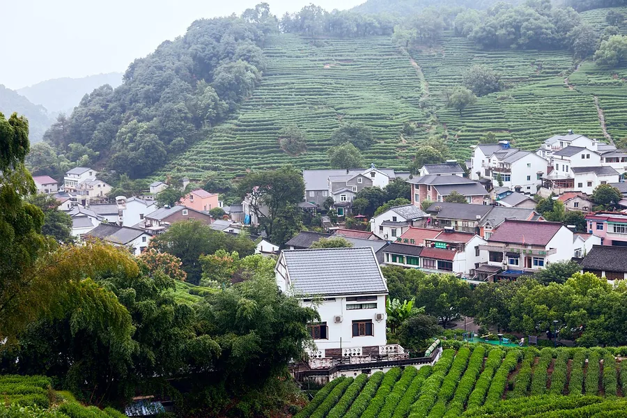 Village houses and tea-growing slopes in the Longjing area of Hangzhou, October 2017.
Longjing, Hangzhou龙井村
Longjing village gives its name to the tea grown on the hills southwest of West Lake. The village landscape brings together tea gardens, teahouses and the old Dragon Well, connecting a familiar drink with its place of…
Read the place guide → AI illustration; an interpretive view, not a photograph. AI 示意图,非景点实拍。
Longjing Tea Fields龙井茶园
The tea fields around Longjing Village follow the contours of the hills below Lion Peak. Rows of low tea bushes make the working landscape unusually readable, with village houses and teahouses close to the plantations. This…
Read the place guide →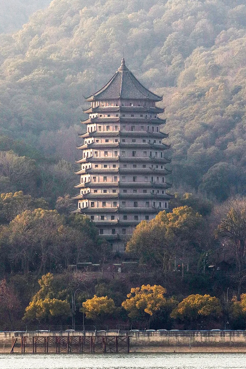 Liuhe Pagoda viewed from across the Qiantang River. Photo: 2024-01-28 16:24:14.
Liuhe Pagoda六和塔
Liuhe Pagoda rises above the Qiantang River at the foot of Yuelun Hill. Its brick interior and timber exterior create a distinctive difference between the seven internal levels and the many tiers of eaves seen outside. The…
Read the place guide → Tea fields at the China National Tea Museum grounds. Photo: 2016-09-27 12:19.
China National Tea Museum中国茶叶博物馆
China National Tea Museum connects tea leaves with the objects, trade and customs surrounding them. The Shuangfeng branch sits within the tea-growing landscape west of West Lake, with displays on tea history, varieties and…
Read the place guide →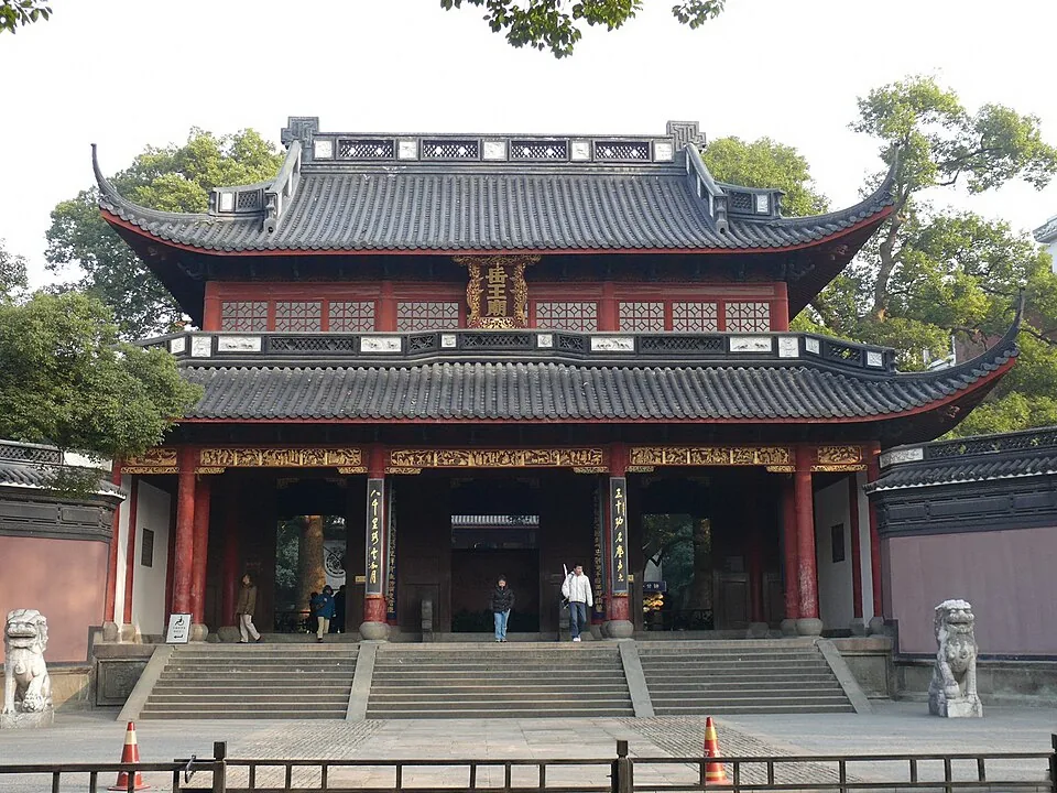 Yue Fei Temple · 岳王庙. Photo: 2010-01-01.
Yue Fei Temple岳王庙
Yue Fei Temple combines a memorial shrine with the tomb precinct of the Southern Song general and his son. The halls explain his later veneration, while the spirit-way sculptures and tomb setting make the memorial landscape…
Read the place guide → Baochu Pagoda · 保俶塔. Photo: 2006-07-26.
Baochu Pagoda保俶塔
Baochu Pagoda makes a slender landmark above the north side of West Lake. The present brick-and-stone tower follows a 1933 rebuilding and has no internal staircase, so the visit centres on its exterior and the paths of Baoshi…
Read the place guide → The 20th-anniversary gateway of Xiling Seal Art Society. Photo: 2014-04-16 10:18:48.
Xiling Seal Art Society西泠印社
Xiling Seal Art Society occupies a hillside garden on the western side of Gushan. Its buildings and inscriptions connect the landscape of West Lake with seal carving, calligraphy and the study of old writing. The small scale…
Read the place guide → The main hall of Zhejiang Provincial Museum's Gushan branch, February 2012.
Zhejiang Provincial Museum浙江省博物馆
Zhejiang Provincial Museum has two distinct visitor settings. The Gushan branch beside West Lake includes Wenlan Pavilion, a historic library complex with courtyards and a water garden. The much larger Zhijiang branch presents…
Read the place guide → A seasonal flower display at Hangzhou Botanical Garden, photographed in November 2024.
Hangzhou Botanical Garden杭州植物园
Hangzhou Botanical Garden spreads across Taoyuanling northwest of West Lake. Its themed plant collections offer a slower visit than the lake’s busiest shoreline. Lingfeng is especially associated with plum and wintersweet…
Read the place guide →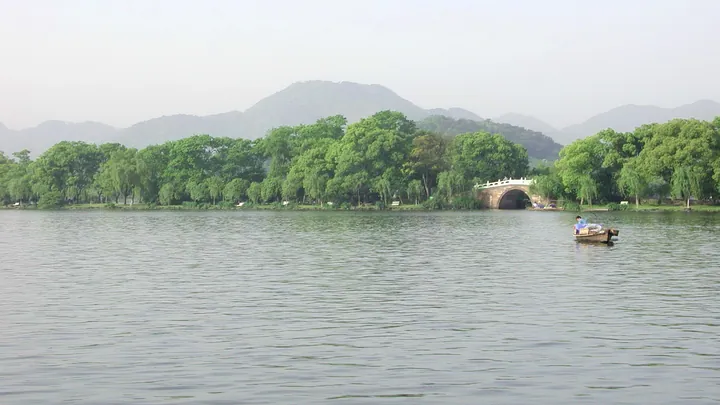 West Lake shoreline with a stone bridge along Su Causeway, Hangzhou · 杭州西湖苏堤沿岸与石拱桥 Source-recorded photograph date: Taken on 13 April 2002.
Spring Dawn at Su Causeway苏堤春晓
Su Causeway crosses the western part of West Lake on a long line of trees and six bridges. It was formed during Su Shi’s lake-dredging work in 1089, turning excavated material into a useful north–south connection. The bridges…
Read the place guide → A stone arched bridge carrying a double-eaved pavilion, rising above a dense field of lotus leaves with brown seed pods, willow fronds hanging into the right of the frame, under a blank white sky.
Wind and Lotus at the Crooked Courtyard (in Summer)曲院风荷
Quyuan Fenghe is West Lake’s lotus-focused garden near the northern end of Su Causeway. Its name recalls a Song-period brewing place and the scent of lotus flowers moving over the water. Paths, bridges and planted pools provide…
Read the place guide →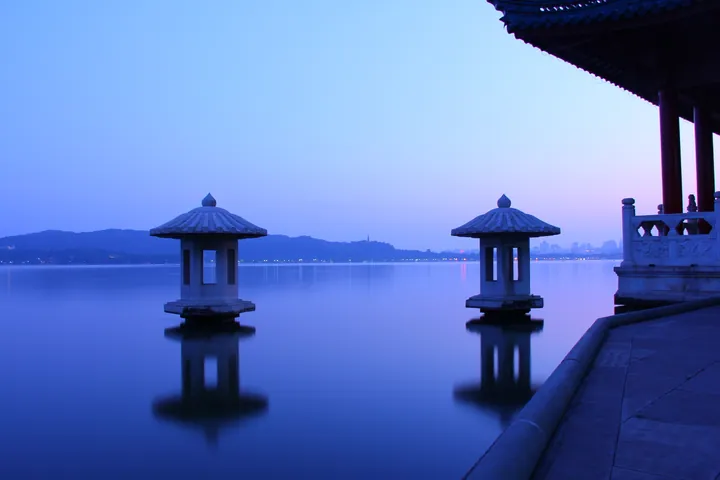 A blue-hour view over glassy West Lake: two stone lantern pagodas standing in the water with mirrored reflections, a moon-viewing terrace and pavilion eave at the right, and the city skyline and hills faint on the far shore.
Autumn Moon over the Calm Lake平湖秋月
Autumn Moon over the Calm Lake occupies a low terrace at Gushan’s southeast corner, where Bai Causeway reaches the island. The platform projects over the water, making this a close-to-the-lake view rather than a hilltop…
Read the place guide → Snow at the Broken Bridge area of West Lake, photographed in December 2018. Photograph date recorded by the source: 2018-12-09.
Lingering Snow on Broken Bridge断桥残雪
Broken Bridge joins Beishan Road to the eastern end of Bai Causeway. The bridge is intact; its name belongs to a group of stories and winter views rather than a missing span. The present bridge dates to a twentieth-century…
Read the place guide → Viewing Fish at Flower Pond · 花港观鱼
Viewing Fish at Flower Pond花港观鱼
Flower Harbor’s fishpond and peony garden create a compact change of scale from West Lake’s broad water. Visitors gather around the red carp pond, while the Peony Pavilion anchors a separate planted area. The traditional name…
Read the place guide → Two carved stone pagoda lanterns standing in bright blue rippled water with a wooded shoreline behind; the third pagoda is out of frame.
Three Ponds Mirroring the Moon三潭映月小瀛洲
Three Ponds Mirroring the Moon combines Xiaoyingzhou island’s garden with three small stone towers standing in the water to its south. Within the island, crossing paths divide pools so that the garden seems to hold a lake inside…
Read the place guide → Evening Bell Ringing on Nanping Hill · 净慈寺南屏晚钟
Evening Bell Ringing on Nanping Hill净慈寺南屏晚钟
The Evening Bell scene centres on Jingci Temple at the foot of wooded Nanping Hill. The bell tower and Buddhist halls give the place a clear focus even when no bell is sounding. Inside the complex, the Wood-Carrying Well belongs…
Read the place guide →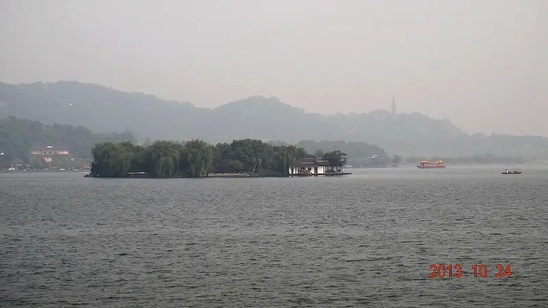 Mid-Lake Pavilion · 湖心亭
Mid-Lake Pavilion湖心亭
Mid-Lake Pavilion stands on a small island in the open water of West Lake. Its buildings and trees form a compact silhouette, different from the larger garden island of Xiaoyingzhou. A stone inscription known as “Chong Er” plays…
Read the place guide → Willows beside Bai Causeway on West Lake · 白堤 Photograph date recorded by the source: 19 September 2021.
Bai Causeway白堤
Bai Causeway provides a direct waterside route from Broken Bridge to Gushan and the Autumn Moon terrace. Jindai Bridge interrupts the planted strip, opening views across different sections of the lake. The causeway’s older name…
Read the place guide → AI illustration · AI 示意图(仅供参考,非该地点实拍)
Solitary Hill and Zhongshan Park孤山及中山公园
Gushan, or Solitary Hill, is West Lake’s natural island, connected to the shore by bridges and Bai Causeway. Zhongshan Park and the surrounding paths offer trees, slopes and close lake views, while cultural buildings give the…
Read the place guide → The tree-lined Yanggong Causeway in Hangzhou · 杨公堤 Photograph date recorded by the source: 18 September 2021.
Yanggong Causeway杨公堤
Yanggong Causeway follows West Lake’s western side through smaller waters and planted banks. Built under the magistrate Yang Mengying in the Ming period, it linked low islands that later became attached to the shore as the lake…
Read the place guide →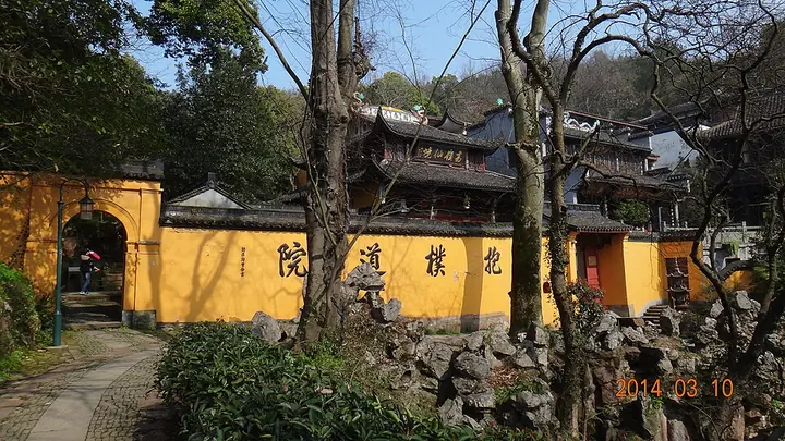 Baopu Taoist Temple on Baoshi Hill, photographed in March 2014 · 抱朴道院 Photograph date recorded by the source: Taken on 10 March 2014.
Baopu Taoist Temple抱朴道院
Baopu Taoist Temple occupies the slope of Geling above West Lake’s north shore. Yellow walls, tiled roofs and stepped approaches give the complex a recognisable hillside character. The main Gexian Hall honours Ge Hong, while…
Read the place guide →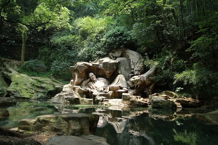 The tiger-and-monk sculptures at Hupao Spring · 虎跑梦泉 Photograph date recorded by the source: 23 June 2007.
Dreaming of the Tiger Spring虎跑梦泉
Tiger Spring lies within a wooded park southwest of West Lake, where streams, bamboo and shaded paths lead toward the spring itself. Its water is closely associated with the local tradition of preparing Longjing tea. The grounds…
Read the place guide → The stone-paved trail alongside the stream at Nine Creeks and Eighteen Gullies, West Lake District, Hangzhou · 杭州西湖区九溪十八涧沿溪石径 Source-recorded photograph date: Taken on 18 April 2009.
Nine Creeks and Eighteen Gullies九溪十八涧
Nine Creeks follows a valley between Longjing Village and Jiuxi Village, with streams crossing a landscape of tea fields and woodland. The attraction is the changing pattern of water, cultivated slopes and shaded paths rather…
Read the place guide →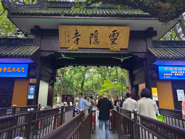 The east gate of the 灵隐飞来峰 scenic area: a dark timber gateway with grey tiled eaves and a gold plaque lettered 靈隱寺, ticket turnstiles and railings leading through it, visitors queuing, and electronic notice screens on both flanking walls beneath the trees.
Lingyin Temple and Feilai Peak灵隐寺与飞来峰
Lingyin Temple and Feilai Peak form a Buddhist and rock-carving landscape in the hills west of central Hangzhou.
Read the place guide → Terraced rows of low tea bushes covering a hillside, rising past a white farm building and a small structure on the slope, with a grey stone marker in the foreground lettered 杭州市都市农业示范园区 / 西湖龙井茶——龙井村, and leafy branches overhanging the top corners.
Longjing Village and Meijiawu Tea Hills龙井村与梅家坞茶山
Longjing Village and Meijiawu are separate tea-growing areas in the hills around Hangzhou's West Lake.
Read the place guide →Plan your visit
Getting there
Xihu District covers the centre of Hangzhou. Search for 西湖区 in a map app to find stations and your accommodation.
Where to stay →Build your route
West Lake and Lingyin Temple are about 5 km apart in a straight line. The linked place guides have entrance and visit details.
Continue with Hangzhou →More in Hangzhou
Sources & geographic information
Administrative names and parent areas: Official geographic directory · Reference date 2026-09-06.
Some facts checked against 西湖区 — Wikipedia contributors, CC BY-SA 4.0.
Some facts checked against 西溪湿地 — Wikipedia contributors, CC BY-SA 4.0.
Photo: West Lake · Takashishin · CC BY 4.0. Wikimedia thumbnail; fitted to the ranking-card frame.

Photo: Lingyin Temple · Tyg728 · CC BY-SA 4.0. Wikimedia thumbnail; fitted to the ranking-card frame.

Photo: Xixi National Wetland Park · Yoshi Canopus · CC BY-SA 3.0. Wikimedia thumbnail; fitted to the ranking-card frame.

Photo: Songcheng · kanegen · CC BY 2.0. Wikimedia thumbnail; fitted to the ranking-card frame.
.jpg)
Photo: Feilai Feng · Gisling · CC BY-SA 3.0. Wikimedia thumbnail; fitted to the ranking-card frame.

Photo: Longjing, Hangzhou · Niklas Dougherty · CC BY-SA 4.0. Proportionally resized and converted to WebP without cropping, retouching or changing the photographed subject.

Photo: Liuhe Pagoda · Windmemories · CC BY-SA 4.0. Converted to WebP and resized without changing the subject or cropping the source frame.

Photo: China National Tea Museum · Fredlyfish4 · CC BY-SA 4.0. Converted to WebP and resized without changing the subject or cropping the source frame.

Photo: Yue Fei Temple · © Peter Potrowl · CC BY 3.0. Converted to WebP and resized without changing the subject or cropping the source frame.

Photo: Baochu Pagoda · Chrisguilbeau ( talk ) ( Uploads ) · CC BY-SA 3.0. Converted to WebP and resized without changing the subject or cropping the source frame.

Photo: Xiling Seal Art Society · Inhorw · CC BY-SA 4.0. Converted to WebP and resized without changing the subject or cropping the source frame.

Photo: Zhejiang Provincial Museum · LukeLOU · CC BY-SA 3.0. Proportionally resized and converted to WebP without cropping, retouching or changing the photographed subject.

Photo: Hangzhou Botanical Garden · Yumeto · CC BY-SA 4.0. Converted to WebP and resized without changing the subject or cropping the source frame.

Photo: Spring Dawn at Su Causeway · lienyuan lee · CC BY 3.0. Full frame retained; proportionally resized and converted to WebP. No retouching or changes to the photographed subject. Card displays may crop the view.
.jpg)
Photo: Wind and Lotus at the Crooked Courtyard (in Summer) · Unknown author · CC BY-SA 3.0. Full frame retained; proportionally resized and converted to WebP. No retouching or changes to the photographed subject. Card displays may crop the view.

Photo: Autumn Moon over the Calm Lake · Jeff chenqinyi · CC BY-SA 3.0. Full frame retained; proportionally resized and converted to WebP. No retouching or changes to the photographed subject. Card displays may crop the view.

Photo: Lingering Snow on Broken Bridge · 94rain · CC BY-SA 4.0. Full frame retained; proportionally resized and converted to WebP. No retouching or changes to the photographed subject. Card displays may crop the view.

Photo: Viewing Fish at Flower Pond · lienyuan lee · CC BY 3.0. EXIF orientation normalized; resized without changing aspect ratio; converted to WebP. No subject edits.

Photo: Three Ponds Mirroring the Moon · lienyuan lee · CC BY 3.0. Full frame retained; proportionally resized and converted to WebP. No retouching or changes to the photographed subject. Card displays may crop the view.

Photo: Evening Bell Ringing on Nanping Hill · Tyg728 · CC BY-SA 4.0. EXIF orientation normalized; resized without changing aspect ratio; converted to WebP. No subject edits.

Photo: Mid-Lake Pavilion · zhiyin586 (Panoramio) · CC BY 3.0. EXIF orientation normalized; resized without changing aspect ratio; converted to WebP. No subject edits.

Photo: Bai Causeway · 钉钉 · CC BY-SA 4.0. Full frame retained; proportionally resized and converted to WebP. No retouching or changes to the photographed subject. Card displays may crop the view.

Photo: Yanggong Causeway · 钉钉 · CC BY-SA 4.0. Full frame retained; proportionally resized and converted to WebP. No retouching or changes to the photographed subject. Card displays may crop the view.

Photo: Baopu Taoist Temple · zhiyin586 (Panoramio) · CC BY 3.0. Full frame retained; proportionally resized and converted to WebP. No retouching or changes to the photographed subject. Card displays may crop the view.

Photo: Dreaming of the Tiger Spring · Sh1019 · CC BY-SA 3.0. Full frame retained; proportionally resized and converted to WebP. No retouching or changes to the photographed subject. Card displays may crop the view.

Photo: Nine Creeks and Eighteen Gullies · zhiyin586 (Panoramio) · CC BY 3.0. Full frame retained; proportionally resized and converted to WebP. No retouching or changes to the photographed subject. Card displays may crop the view.

Photo: Lingyin Temple and Feilai Peak · Liuxingy · CC BY-SA 4.0. Full frame retained; proportionally resized and converted to WebP. No retouching or changes to the photographed subject. Card displays may crop the view.

Photo: Longjing Village and Meijiawu Tea Hills · Tyg728 · CC BY-SA 4.0. Full frame retained; proportionally resized and converted to WebP. No retouching or changes to the photographed subject. Card displays may crop the view.

Map data © OpenStreetMap contributors. Pins mark approximate centres, not entrances or boundaries.