


About Inner Mongolia
Inner Mongolia at a glance
- Population
- 23,740,000Year-end resident population, entire provincial-level administrative area · 2025Source ↗
- Income per person
- 41,921Mean annual disposable income per person, all residents · 2025 · CNYSource ↗
- Languages & dialects
- Mandarin/Chinese (汉语) and Mongolian (蒙古语); other community languages are also present.Source ↗
- Geography
- A northern plateau region spanning forests, grasslands, plains and western deserts; borders Mongolia and Russia.Source ↗
- Elevation
- Much of the region lies above 1,000 m; eastern plains and mountain areas differ considerably.Source ↗
- Main gateway
- HohhotAutonomous region

Discover Inner Mongolia
Begin with the right regional gateway
Hohhot suits a first look at the central region, with Dazhao, Saishang Old Street and museum visits providing context before an excursion outside the city. Hailar serves a different travel project in Hulunbuir. Around Ergun, grassland meets wetland and forest, with river settlements contributing their own settings. These gateways are not interchangeable. A route that allows time for one region's towns and surrounding landscapes is easier to understand than a succession of widely separated highlights.
Look beyond a single grassland image
The Baotou area offers the monastery landscape of Wudangzhao, while the Ordos region includes developed desert recreation at Xiangshawan. A managed dune resort, a wetland visit and a working pastoral landscape are different experiences. Match expectations to the particular place and ask what an activity actually includes. In towns and countryside alike, Mongolian and Chinese traditions form part of a varied cultural setting; local homes, religious spaces and livestock should be approached with permission and consideration.
Plan remote nights as carefully as the scenery
Food ranges from Hohhot's lamb shaomai and salty milk tea to shared meat dishes and dairy preparations. Give ordinary city meals time alongside countryside experiences. For a remote stay, distinguish visitor yurts from working-family accommodation and confirm heating, bathrooms, meals and onward travel. Regional and seasonal weather differences are substantial: northeastern winters, windy grasslands and dry western areas call for different preparation. A clear sequence of bases matters more than collecting a fixed list of activities.
Explore Inner Mongolia
Core places to explore, with English and Chinese names.
Dazhao Temple 大召寺
Inner Mongolia Museum 内蒙古博物院
Five Pagoda Temple 五塔寺
Zhaojun Tomb 昭君墓
Great Mosque of Hohhot 呼和浩特清真大寺
Wudang Lamasery 五当召
Meidaizhao 美岱召
Wuhai 乌海
Hexigten Global Geopark 克什克腾世界地质公园
Dali Lake 达里诺尔
Daqinggou 大青沟
Mausoleum of Genghis Khan 成吉思汗陵
Ordos Museum 鄂尔多斯博物馆
Kubuqi Desert 库布齐沙漠
Xiangshawan 响沙湾
Ordos: Kangbashi 鄂尔多斯康巴什
Hulun Lake 呼伦湖
Manzhouli 满洲里
Hailar, Hulunbuir 呼伦贝尔海拉尔
Ergun wetlands 额尔古纳湿地
Shiwei 室韦
Urad Grassland 乌拉特草原
Daihai Lake 岱海
Arxan 阿尔山
Ulanhot 乌兰浩特
Xanadu Ruins 元上都遗址
Beizi Temple 贝子庙
Badain Jaran Desert 巴丹吉林沙漠
Khara-Khoto 黑城遗址
Tengger Desert 腾格里沙漠
Juyan Lake 居延海
Hohhot 呼和浩特
Baotou 包头
Xilinhot 锡林浩特
Ejin Banner 额济纳旗
Arxan National Forest Park 阿尔山国家森林公园
Manzhouli Matryoshka Square 满洲里套娃广场
Manzhouli Beihu Park 满洲里北湖公园
Chunkun Mountain 春坤山
Wuhai Lake 乌海湖
Liao Upper Capital Ruins 辽上京遗址
Liao Shangjing Museum 辽上京博物馆
Khan Mountain 可汗山
Mordaoga National Forest Park 莫尔道嘎国家森林公园
Wuliangsuhai Lake 乌梁素海
Duolun Luanhe Headwaters Wetland Park 多伦滦河源国家湿地公园
Xilitu Temple 席力图召
Saishang Old Street 塞上老街
Princess Kejing Mansion Museum 和硕恪靖公主府博物馆
Hohhot City Museum 呼和浩特博物馆
Inner Mongolia Art Museum 内蒙古美术馆
Baotou Museum 包头博物馆
Chifeng Museum 赤峰博物馆
Hongshan National Forest Park 红山国家森林公园
Harqin Prince’s Mansion 喀喇沁亲王府
Manzhouli National Gate Visitor Center 满洲里国门景区游客中心
Erguna Birch Forest Visitor Center 额尔古纳白桦林景区游客中心
Ulan Hot Genghis Khan Temple 乌兰浩特成吉思汗庙
Manzhouli China-Russia Border Tourism Area 满洲里中俄边境旅游区
Morigele River Scenic Area 莫尔格勒河景区
Asihatu Stone Forest 阿斯哈图石林
Ejina Poplar Forest Tourism Area 额济纳胡杨林旅游区
Laoniuwan Yellow River Grand Canyon 老牛湾黄河大峡谷
Chaihe Moon Town 柴河月亮小镇
Hasuhai Lake 哈素海
Xilamuren Grassland 希拉穆仁草原
Wulanbutong Grassland 乌兰布统
Asihatu Stone Formations 阿斯哈图石阵
Gongger Grassland 贡格尔草原
Dali Lake 达里湖
Huanggangliang Mountain 黄岗梁
Daoxugou Valley 道须沟
Hongshan Culture Museum 红山文化博物馆
Naiman Prince's Mansion 奈曼王府
Baogutu Desert 宝古图沙漠
Kulun Three Temples 库伦三大寺
Yinshawan Desert 银沙湾
Hamin Archaeological Site 哈民遗址
Xiaozhuang Park 孝庄园
Qixing Lake Desert Scenic Area 七星湖沙漠旅游区
Aoluguya Reindeer Tribe Scenic Area 敖鲁古雅使鹿部落景区
Manzhouli China-Russia Border Scenic Area 中俄边境旅游区
Manzhouli Matryoshka Doll Scenic Area 套娃景区
Gaxian Cave 嘎仙洞
Darbin Lake Forest Park 达尔滨湖森林公园
Enhe Russian Ethnic Township 恩和俄罗斯族民族乡
Ergun White Birch Forest Scenic Area 白桦林景区
Genghis Khan Temple 成吉思汗庙
Wulanmaodu Grassland 乌兰毛都草原
Arxan Railway Station 阿尔山火车站
Wulagai Nine Bends 乌拉盖九曲湾
Duolun Lake 多伦湖
Xilinhot Pingding Mountain 平顶山
Huitengxile Grassland 辉腾锡勒草原
Huanghuagou Canyon 黄花沟
Wulanhada Volcanoes 乌兰哈达火山
Badain Jaran Desert Scenic Area 巴丹吉林沙漠开放旅游区
Tengger Desert Scenic Area 腾格里沙漠开放旅游区
Helan Mountain Guangzong Monastery 贺兰山广宗寺
Strange Tree Forest 怪树林
Huanghuagou Grassland Tourism Resort 黄花沟草原旅游度假区
Wulanbutong Grassland 乌兰布统
Wulanhada Volcano Geopark 乌兰哈达火山地质公园
Hulunbuir Grasslands 呼伦贝尔大草原
Manzhouli Guomen Scenic Area 满洲里国门景区
Sino-Russian Border Tourist Area Of Manzhouli 满洲里市中俄边境旅游区
Inner Mongolia local specialties
内蒙古特色美食 · 110 specialties to discover
 Lamb shaomai 羊肉烧麦
Lamb brings richness and a distinctive aroma, balanced by scallion; the wrapper is delicate at the rim and slightly chewy below.
Source ↗Read the dish guide →Photo adjustments
EXIF orientation applied where present; resized proportionally to at most 640 px on the long edge and encoded as WebP. No crop, retouching, recoloring or subject changes.
 Lamb offal soup 羊杂碎汤
Each cut contributes a different chew, from soft to resilient, while the broth carries a pronounced lamb flavor. Chili and aromatics can make the bowl more assertive.
Source ↗Read the dish guide →Photo adjustments
EXIF orientation applied where present; resized proportionally to at most 640 px on the long edge and encoded as WebP. No crop, retouching, recoloring or subject changes.
 Salty milk tea 咸奶茶
The flavor is savory and milky, with tea tannin underneath. Added millet changes from crisp to soft as it soaks.
Source ↗Read the dish guide →Photo adjustments
EXIF orientation applied where present; resized proportionally to at most 640 px on the long edge and encoded as WebP. No crop, retouching, recoloring or subject changes.
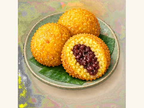 Yellow fried grain cakes 黄米炸糕AI dish illustration · AI 菜品示意图
A crisp shell gives way to a dense, elastic middle with a mild grain sweetness. Filled versions add a softer, sweeter center.
Source ↗Read the dish guide → Shoubarou 手把肉
The meat's own flavor leads, with tender flesh contrasting with richer fatty sections. The broth can be a valuable part of the meal.
Source ↗Read the dish guide →Photo adjustments
EXIF orientation applied where present; resized proportionally to at most 640 px on the long edge and encoded as WebP. No crop, retouching, recoloring or subject changes.
 Milk curd 奶豆腐
Fresh milk curd can be mildly sour and chewy, while drier pieces are more concentrated and firm. Sweetened preparations taste different from plain ones.
Source ↗Read the dish guide →Photo adjustments
EXIF orientation applied where present; resized proportionally to at most 640 px on the long edge and encoded as WebP. No crop, retouching, recoloring or subject changes.
 Air-dried beef 风干牛肉
Some pieces are tough and fibrous enough to tear slowly; others are softer, with pepper, chili or cumin becoming prominent.
Source ↗Read the dish guide →Photo adjustments
Resized proportionally to a maximum 640 px long edge, EXIF orientation applied where present, and encoded as WebP. No crop or subject alteration.
 Hohhot beizi flatbread 呼市焙子AI illustration · AI 示意图
A browned outer crust opens into a soft, layered center, with a fuller, more substantial bite than a delicate pastry. Freshness makes a noticeable difference to the flakiness.
Source ↗Read the dish guide →All dish names · 全部菜名 (110)
- Lamb shaomai · 羊肉烧麦
- Lamb offal soup · 羊杂碎汤
- Salty milk tea · 咸奶茶
- Yellow fried grain cakes · 黄米炸糕
- Shoubarou · 手把肉
- Milk curd · 奶豆腐
- Air-dried beef · 风干牛肉
- Hohhot beizi flatbread · 呼市焙子
- Tuoketuo stewed fish · 托县炖鱼
- Baotou millet tea paste · 包头老茶汤
- Chifeng duijia sandwich · 赤峰对夹
- Nantun simmered beef ribs · 水煮南屯牛排
- Buryat steamed buns · 布里亚特包子
- Russian-style leba bread · 俄罗斯列巴
- Ordos pork and cabbage stew · 腌猪肉烩小白菜
- Arxan chicken with mushrooms and noodles · 小鸡炖蘑菇粉
- Horqin meat pies · 科尔沁蒙古馅饼
- Mongolian roasted millet · 炒米
- Xilingol stone-cooked lamb · 石头烤肉
- Hetao braised noodles · 河套焖面
- Zhuozishan smoked chicken · 卓资山熏鸡
- Fengzhen mooncake · 丰镇月饼
- Alxa camel meat pie · 驼肉馅饼
- Alxa shami jelly · 沙米凉粉
- Mongolian milk skin · 蒙古奶皮子
- Mongolian cultured cream · 蒙古奶嚼口
- Harqin sticky bean buns · 喀喇沁黏豆包
- Hure buckwheat noodles · 库伦荞面
- Tsegee fermented mare's milk · 策格酸马奶
- Dahan Slow-Cooked Oxtail · 大汉牛尾
- Inner Mongolian Whole Roast Lamb · 内蒙古烤全羊
- Air-Dried Lamb Back · 风干羊背子
- Chilechuan Celebration Banquet Dish · 欢庆敕勒川
- Oxtail in Nourishing Golden Broth · 金汤滋补牛尾
- Jinsui Lamb Testicles · 金穗羊宝
- Roast Lamb Spine · 烤羊脊
- Hongyun Dangtou Banquet Dish · 鸿运当头
- Hongyun Lamb Brisket · 鸿运羊腩
- Salt-Baked Lamb Testicles with Goose Egg · 鹅蛋盐焗菊花羊宝
- Hohhot Shaomai Dumplings · 呼和浩特烧麦
- Beizi Baked Flatbread · 焙子
- Sheep Offal in Broth · 羊杂碎
- Wuchuan Naked-Oat Noodles · 武川莜面
- Mongolian Milk Tea · 蒙古奶茶
- Shaomai Steamed Dumplings · 稍麦
- Mutton-Stuffed Pancake · 羊肉馅饼
- Mongolian Milk Skin · 奶皮子
- Baotou Shaomai Dumplings · 包头烧麦
- Beiguozi Hotpot · 背锅子
- Chatang Millet Flour Pudding · 茶汤
- Hand-Torn Boiled Meat · 手扒肉
- Iron-Pot Braised Noodles · 铁锅焖面
- Guyang Naked-Oat Noodles · 固阳莜面
- Damao Roast Saddle of Lamb · 达茂烤羊背
- Yellow River Spring Thaw Fish · 黄河开河鱼
- Lamb Shaomai Dumplings · 羊肉烧卖
- Wuhai Grape Chicken · 乌海葡萄鸡
- Wuhai Stewed Arbas Goat · 炖羊肉
- Roast Lamb Ribs · 烤羊排
- Scrambled Eggs with Sand Onion · 沙葱炒鸡蛋
- Yellow River Fish · 黄河鱼
- Hand-Held Boiled Mutton · 手扒羊肉
- Hada Flatbread · 哈达饼
- Aohan Flicked Buckwheat Noodles · 敖汉拨面
- Crispy Sweet and Sour Pork · 锅包肉
- Mongolian Meat Pie · 蒙古馅饼
- Mongolian Sheep Blood Sausage · 羊盘肠
- Roast Leg of Lamb · 烤羊腿
- Buckwheat Pressed Noodles · 荞面饸饹
- Naiman Whole Lamb Banquet · 奈曼全羊宴
- Horqin Beef Jerky · 科尔沁牛肉干
- Milk Tea with Roasted Millet · 炒米奶茶
- Blood Sausage · 血肠
- Meat Sausage · 肉肠
- Sour Fermented Grain Porridge · 酸粥
- Whole Lamb Back · 羊背子
- Zhama Mongolian Banquet · 诈马宴
- Stir-Fried Lamb with Sand Onion · 沙葱羊肉
- Ordos Dairy Foods · 鄂尔多斯奶食
- Mutton-Fat Fried Dough Twists · 羊油馓子
- Air-Dried Mutton · 风干羊肉
- Hand-Held Boiled Mutton · 手把羊肉
- Jungar Stewed Mutton · 准格尔炖羊肉
- Wild Wormwood Shoots · 柳蒿芽
- Salty Milk Tea · 奶茶
- Hulun Lake Whole Fish Banquet · 呼伦湖全鱼宴
- Evenki Grilled Meat · 鄂温克烤肉
- Bayannur Mixed Stew · 巴盟烩菜
- Hetao Cold Wheat Sheet Noodles · 河套面筋
- Pork and Chicken Braise · 猪肉勾鸡
- Fried Millet Cakes · 油炸糕
- Wallace Melon Tossed with Milk Skin · 华莱士瓜拌奶皮
- Lamb with Broth-Soaked Roasted Millet · 羊肉泡炒米
- Naked-Oat Flour Noodles · 莜面
- Liangcheng Chopped Sheep Offal · 凉城县羊杂碎
- Chayouhouqi Red-Braised Lamb · 察右后旗红炖羊肉
- Potato Banquet · 土豆宴
- Wang Xiao'er Big Flatbread · 王小二大饼
- Horqin Hand-Held Boiled Lamb · 科尔沁手把肉
- Pot-Cooked Tea · 锅茶
- Xilingol Hand-Held Boiled Mutton · 锡林郭勒手把肉
- Ujimqin Mutton · 乌珠穆沁羊肉
- Whole Roast Sheep · 烤全羊
- Air-Dried Meat · 风干肉
- Alxa Whole Roast Lamb · 阿拉善烤全羊
- Scrambled Eggs with Sand Onion · 沙葱炒蛋
- Lamb Stewed with Suoyang Herb · 锁阳炖羊肉
- Camel Paw · 驼掌
- Camel Meat Pie · 骆驼肉馅饼
- Juyan Sweet Melon Pastry · 居延蜜瓜酥
Top sights in Inner Mongolia
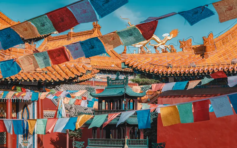 TOP1呼和浩特
Dazhao anchors the temple quarter of old Hohhot. Its main hall combines Chinese and Tibetan building forms and preserves a celebrated silver image of Shakyamuni. Golden dragons coil around the columns in front of the image…
 TOP2鄂尔多斯
Xiangshawan combines a high crescent-shaped sand slope with a developed desert resort at Kubuqi's eastern edge.
 TOP3乌兰察布市
Huanghuagou Grassland Tourism Resort黄花沟草原旅游度假区
Show on map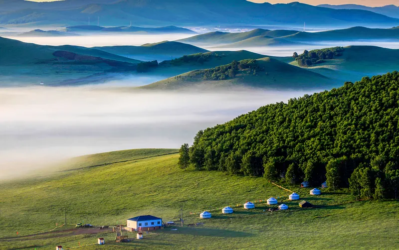 TOP4赤峰市
Wulanbutong in southwestern Hexigten Banner combines rolling grassland, birch woodland, wetlands and sandy country around the historic Ulan Butong battlefield.
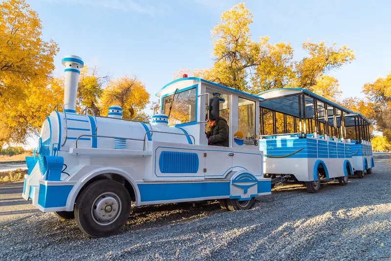 TOP5阿拉善盟
Ejina's poplar forest tourism area links named bridge sections through desert-poplar woodland near Dalaihub Town.
 TOP6乌兰察布市
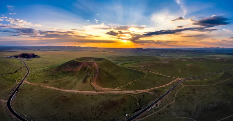
Wulanhada Volcano Geopark乌兰哈达火山地质公园
Show on map TOP7兴安盟
Arxan Forest Park combines volcanic landforms with the forests of the Greater Khingan Range. At Shitanglin, dark solidified lava breaks into an irregular stone landscape, with plants returning between the rocks. Nearby Dujuan…
 TOP8呼伦贝尔市
Hulunbuir Grasslands呼伦贝尔大草原
Show on map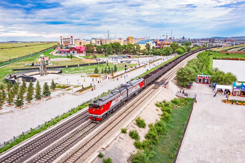 TOP9满洲里市
Manzhouli Guomen Scenic Area满洲里国门景区
Show on map TOP10满洲里市
Sino-Russian Border Tourist Area Of Manzhouli满洲里市中俄边境旅游区
Show on map
 Show on map

.jpg)


Change your destination on Trip.com.
Ranking source & photo credits
The first ten entries of Trip.Best Best Things to Do. Rankings reflect platform recommendations, not counts of international visitors. Read on 20 September 2026; platform pages may use cached snapshots.
- Dazhao Temple: Source: Trip.com · Resized and WebP compressed; fitted to the ranking card.
- Whistling Dune Bay: Source: Trip.com · Resized and WebP compressed; fitted to the ranking card.
- Huanghuagou Grassland Tourism Resort: Source: Trip.com · Resized and WebP compressed; fitted to the ranking card.
- Wulanbutong Grassland: Source: Trip.com · Resized and WebP compressed; fitted to the ranking card.
- Ejina Populus Euphratica Tourist Area: Source: Trip.com · Resized and WebP compressed; fitted to the ranking card.
- Wulanhada Volcano Geopark: Source: Trip.com · Resized and WebP compressed; fitted to the ranking card.
- Arxan National Forest Park: Source: Trip.com · Resized and WebP compressed; fitted to the ranking card.
- Hulunbuir Grasslands: Source: Trip.com · Resized and WebP compressed; fitted to the ranking card.
- Manzhouli Guomen Scenic Area: Source: Trip.com · Resized and WebP compressed; fitted to the ranking card.
- Sino-Russian Border Tourist Area Of Manzhouli: Source: Trip.com · Resized and WebP compressed; fitted to the ranking card.
Cities, counties & districts in Inner Mongolia
12 areas belong directly to Inner Mongolia.
12 areas
Hohhot呼和浩特市
Hohhot, formerly known as Guihua or Kweisui (Guisui), is the capital and largest city of the northern Chinese autonomous region of Inner Mongolia, serving as the region's administrative, economic and cultural…
9 local areas →Prefecture-level cityBaotou包头市
Baotou is the second-largest city by urban population in Inner Mongolia, China. Governed as a prefecture-level city, its built-up (or metro) area within its five urban districts is home to 2,261,089 people…
9 local areas →Prefecture-level cityWuhai乌海市
Wuhai is a prefecture-level city and regional center in the Inner Mongolia Autonomous Region, China, and is by area the smallest prefecture-level division of the region.
3 local areas →Prefecture-level cityChifeng赤峰市
Chifeng is a prefecture-level city in Southeastern Inner Mongolia, People's Republic of China. It borders Xilin Gol League to the north and west, Tongliao to the northeast, Chaoyang (Liaoning) to the…
12 local areas →Show fewer areas
Tongliao通辽市
Tongliao is a prefecture-level city in eastern Inner Mongolia, People's Republic of China. The area is 59,535 square kilometres (22,987 sq mi) and as of the 2020 census, its population was 2,873,168…
8 local areas →Prefecture-level cityOrdos鄂尔多斯市
Ordos, also known as Ih Ju, is one of twelve major subdivisions of Inner Mongolia, China. It lies within the Ordos Plateau of the Yellow River.
9 local areas →Prefecture-level cityHulunbuir呼伦贝尔市
Hulunbuir or Hulun Buir is a prefecture-level city in northeastern Inner Mongolia, China. Its administrative center is located at Hailar District, its largest urban area.
14 local areas →Prefecture-level cityBayannur巴彦淖尔市
Bayannur (Bayan Nur) or Bayannao'er is a prefecture-level city in western Inner Mongolia, People's Republic of China. Until 1 December 2003, the area was called Bayannur League.
7 local areas →Prefecture-level cityUlanqab乌兰察布市
Ulanqab or Ulan Chab is a region administered as a prefecture-level city in south-central Inner Mongolia, China. Its administrative centre is in Jining District, which was formerly a county-level city.
11 local areas →LeagueHinggan League兴安盟
The Hinggan League is a prefecture-level subdivision of the Inner Mongolia Autonomous Region of the People's Republic of China.
6 local areas →LeagueXilingol League锡林郭勒盟
Xilingol League (also transliterated as Xilin Gol or Shiliin Gol; Chinese: 锡林郭勒盟; Mongolian:, Шилийн Гол аймаг, Shiliin Gol aimag, pronounced [ʃɪ̆ˈliŋ ɢɔl ˈɛːmə̆k]) is one of the three leagues of Inner…
12 local areas →LeagueAlxa League阿拉善盟
Alxa League or Alashan League is one of 12 prefecture level divisions and 3 extant leagues, or aimags, of Inner Mongolia.
3 local areas →No areas match this name.
Arrive, stay & get around Inner Mongolia
交通枢纽、住宿与天气
Hohhot呼和浩特
This Inner Mongolia entry uses Hohhot as its selected gateway city. It does not describe transport coverage across the entire region.
Airports
Hohhot Baita International AirportHET
呼和浩特白塔国际机场
Hohhot air gateway. Confirm the departure airport name and terminal on the ticket because the Shengle replacement project has a separate site.
Railway stations
Hohhot East Railway Station
呼和浩特东站
Main high-speed rail gateway east of the older city center.
Hohhot Railway Station
呼和浩特站
Central railway station; do not assume services also call at Hohhot East.
Metro & city transport
Hohhot Metro Network 呼和浩特轨道交通线路图
The official journey planner includes Hohhot East and the Baita-side Bayan Airport terminus. Recheck airport connections during any future transfer to Shengle.
- 1Find your stations确认起点与终点站
- 2Check interchanges查看换乘线路与站点
- 3Follow exit signs到站后按站内标识出站
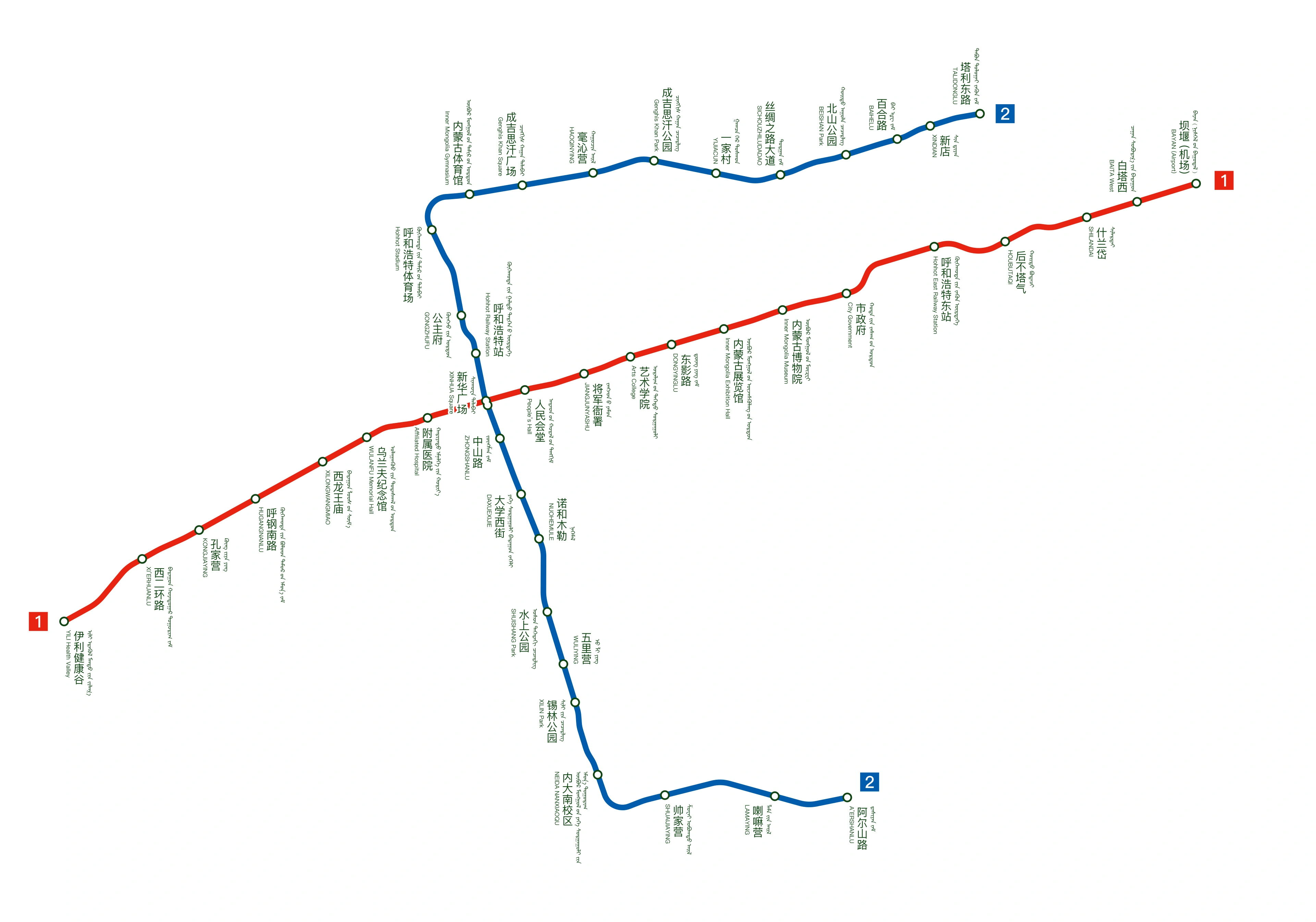 Explore the full network查看站名、线路与换乘Enlarge map点击放大线路图
Check the legend for closed, reserved or future sections. 停运、预留与规划区间,请按图例辨识。
Map edition: 2023-11-17 · Diagram reviewed 2026-09-06
Map: Yveltal · CC BY-SA 4.0
Map coverage & sources 图示范围与来源说明
Complete operating Lines 1 and 2, including Yili Health Valley station name. Source revision is 2023-11-17, checked against currently available operator station listings. Does not depict future new-airport rail proposals.
White background and WebP conversion; no route edits.
Coaches, ferries & onward travel
Chilechuan Grassland sightseeing bus
敕勒川草原观光线
A city sightseeing route toward Chilechuan Grassland; check the current boarding point and operating days before planning a grassland outing.
Transport reference review: 2026-09-06. Consult the operator for current services and timetables.
More about getting around
Use rail or flights to reach your chosen regional hub, then arrange road travel for grasslands and desert sights. Hohhot and Hailar are not interchangeable gateways. Clarify the whole route, vehicle, luggage capacity, and overnight stops before agreeing to a rural transfer package.
Stay in Inner Mongolia
Choose Hohhot for temples and a central-region introduction, or Hailar for a Hulunbuir circuit. Treat resort yurts and working-family stays as different experiences. Before a remote overnight, check heating, bathroom arrangements, meals, and how you will reach the next town.
Find hotels on Trip.com →Change your destination, dates and guests on Trip.com.
Hohhot weather
The current-hour forecast loads when this section is visible. It uses MET Norway model data for the named city, not station observations.
Seasons & when to go
Expect strong seasonal and regional differences. Grassland summers can bring warm days, rain, and cool nights; winters are severe, particularly in the northeast. Dry western areas have intense sun and large temperature swings. Wind protection matters in every season, including seemingly mild weather.
Local life & communication
The region's distinctions are geographic and lived: a capital's temple-and-food streets, northeastern forest-steppe and river communities, western monasteries, and developed desert recreation.
Mongolian music, pastoral food traditions, and Buddhist temples are important threads in a culturally diverse region. Hohhot's Dazhao offers architectural context before a grassland trip. Ask permission before entering a working household, approaching livestock, or photographing people engaged in religious practices.
Language & communication
Mandarin is widely useful in cities and transport settings; Mongolian also appears in speech and signage, alongside other community languages. Place names have several English spellings. Keep Chinese characters for your exact destination and accommodation, especially when an itinerary crosses banners or remote townships.
Useful local tips
- Choose a regional circuit before choosing individual attractions; Hohhot, Ordos and Hulunbuir are not neighboring sightseeing districts.
- Confirm the exact museum building: an official report recorded a new Inner Mongolia Museum site in 2025.
- Grassland is also a place of work and habitat; keep to permitted routes and do not enter private grazing areas for photos.
- Ask whether milk tea is salty and whether a meat dish includes offal; English dish names may hide these differences.
Sources & useful links
- China National Tourist Office: Inner Mongolia
- Hohhot city portal: Saishang Old Street
- Hohhot tourism-bureau material: signature flavors
- Inner Mongolia portal: museum new site
- Hulunbuir government / wetland management bureau
- National Forestry and Grassland Administration: Ergun
- Ordos government: Xiangshawan
- Xilinhot government: regional food event
- Inner Mongolia — population background
- Inner Mongolia — languages background
- Inner Mongolia — geography background
- Inner Mongolia — Hohhot map reference
- Inner Mongolia — Baotou map reference
- Inner Mongolia — Ordos: Kangbashi map reference
- Inner Mongolia — Hailar, Hulunbuir map reference
- Inner Mongolia — Dazhao Temple map reference
- Inner Mongolia — Xiangshawan map reference
- Inner Mongolia — Ergun wetlands map reference
- Inner Mongolia — Manzhouli map reference
- Inner Mongolia — Arxan map reference
- Inner Mongolia — Hulun Lake map reference
- Inner Mongolia — Xilinhot map reference
- Inner Mongolia — Hexigten Global Geopark map reference
- Inner Mongolia — Wudang Lamasery map reference
- Inner Mongolia — Mausoleum of Genghis Khan map reference
- Inner Mongolia — Badain Jaran Desert map reference
- Inner Mongolia — Ejin Banner map reference
- Inner Mongolia — Kubuqi Desert map reference
- Inner Mongolia — Ergun wetlands map reference
- Inner Mongolia attraction ranking source
- Inner Mongolia specialty reference — www.taiwan.cn
- Xilingol government: milk skin
- Wulagai government: dairy food traditions
- 满洲里中俄边境旅游区 — place reference
- 莫尔格勒河景区 — place reference
- 阿斯哈图石林 — place reference
- 额济纳胡杨林旅游区 — place reference
- 老牛湾黄河大峡谷 — place reference
- 喀喇沁黏豆包 — local food reference
- 库伦荞面 — local food reference
- 柴河月亮小镇 — place reference
- Local food reference: 大汉牛尾
- Local food reference: 蒙古奶茶
- Local food reference: 奶皮子
- Local food reference: 油炸糕
- Local food reference: 烤全羊